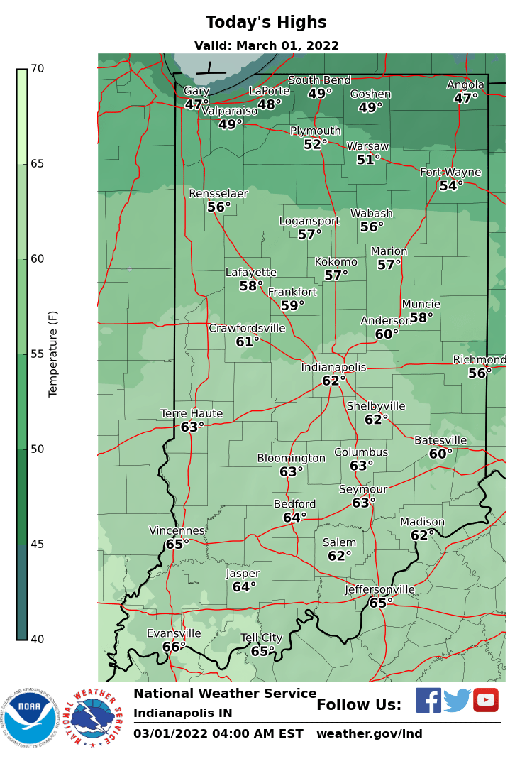
Welcome to March! February ended up wet, with 4.58″ of melted precipitation in Indy. That’s two inches above average. There was 8.3 inches of snow, almost entirely from the ice and snow storm that moved through Indiana from February 2-4. The lowest temperature was 2 on February 5. (We made it to 0 in January.) The warmest was 63, on February 21. We will surpass that by this weekend. Today’s highs will be about 15 degrees above average.
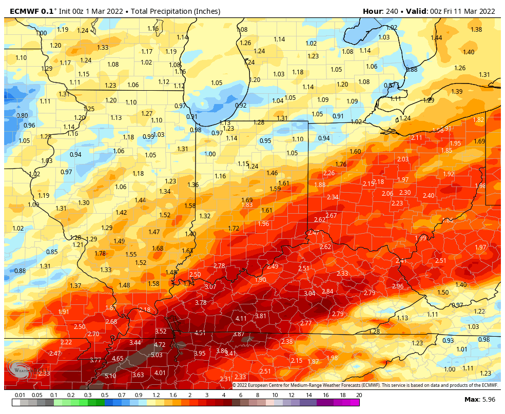
This welcome dry stretch will end with weekend showers (and maybe some thunder). Another – more substantial round of rain is likely Monday and Tuesday. Totals over the next week could exceed an inch, especially south of Indy.
Never miss me! Subscribe for free. My Huge Radar has real-time weather tracking, current temperatures, and severe weather watches and warnings. Get detailed Indiana conditions by clicking here. Click here to see my central Indiana 7-Day Forecast. Follow these links to get my forecasts for Lafayette, Muncie, Hendricks County, and Hamilton County. Need a second opinion? Click here for central Indiana National Weather Service forecasts. (Some charts via WeatherBELL.)
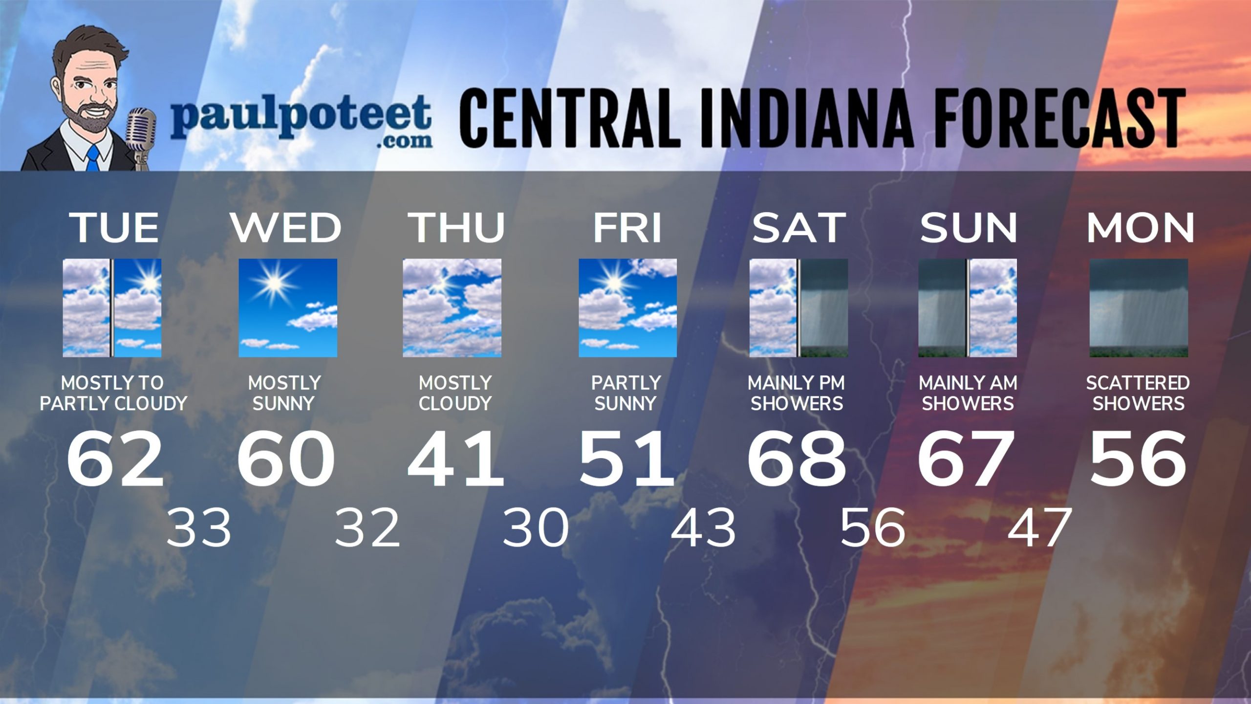
INDY SEVEN DAY FORECAST
Today: Mostly to partly cloudy. High 62.
Tonight: Mostly clear. Low 33.
Wednesday: Mostly sunny. High 60.
Wednesday Night: Partly, then mostly cloudy. Low 32.
Thursday: Mostly cloudy. High 41.
Thursday Night: Partly cloudy. Low 30.
Friday: Partly sunny. High 51.
Friday Night: Mostly cloudy. Low 43.
Saturday: Mostly cloudy. Scattered afternoon showers. High 68.
Saturday Night: Showers likely. Thunder possible. Low 56.
Sunday: Mainly morning showers. Mostly cloudy. High 67.
Sunday Night: Mostly cloudy. Spotty showers. Low 47.
Monday: Mostly cloudy. Scattered showers. High 56.
Never miss me! Subscribe for free. My Huge Radar has real-time weather tracking, current temperatures, and severe weather watches and warnings. Get detailed Indiana conditions by clicking here. Click here to see my central Indiana 7-Day Forecast. Follow these links to get my forecasts for Lafayette, Muncie, Hendricks County, and Hamilton County. Need a second opinion? Click here for central Indiana National Weather Service forecasts. (Some charts via WeatherBELL.)


@Freedom95Radio I dislike March weather. It’s a rollercoaster between Fake Spring and Fake Winter.