Just damp today, but there is a severe weather threat tomorrow for central Indiana. An initial line of strong, but likely sub-severe storms will move through Tuesday morning. Then, additional thunderstorms are expected to develop in the afternoon/evening, providing a severe risk from around 3-9pm.

Expect some clearing Tuesday night, and a dry, hot Wednesday. Wednesday evening brings another round of storms, with an even higher severe threat through the evening and overnight.

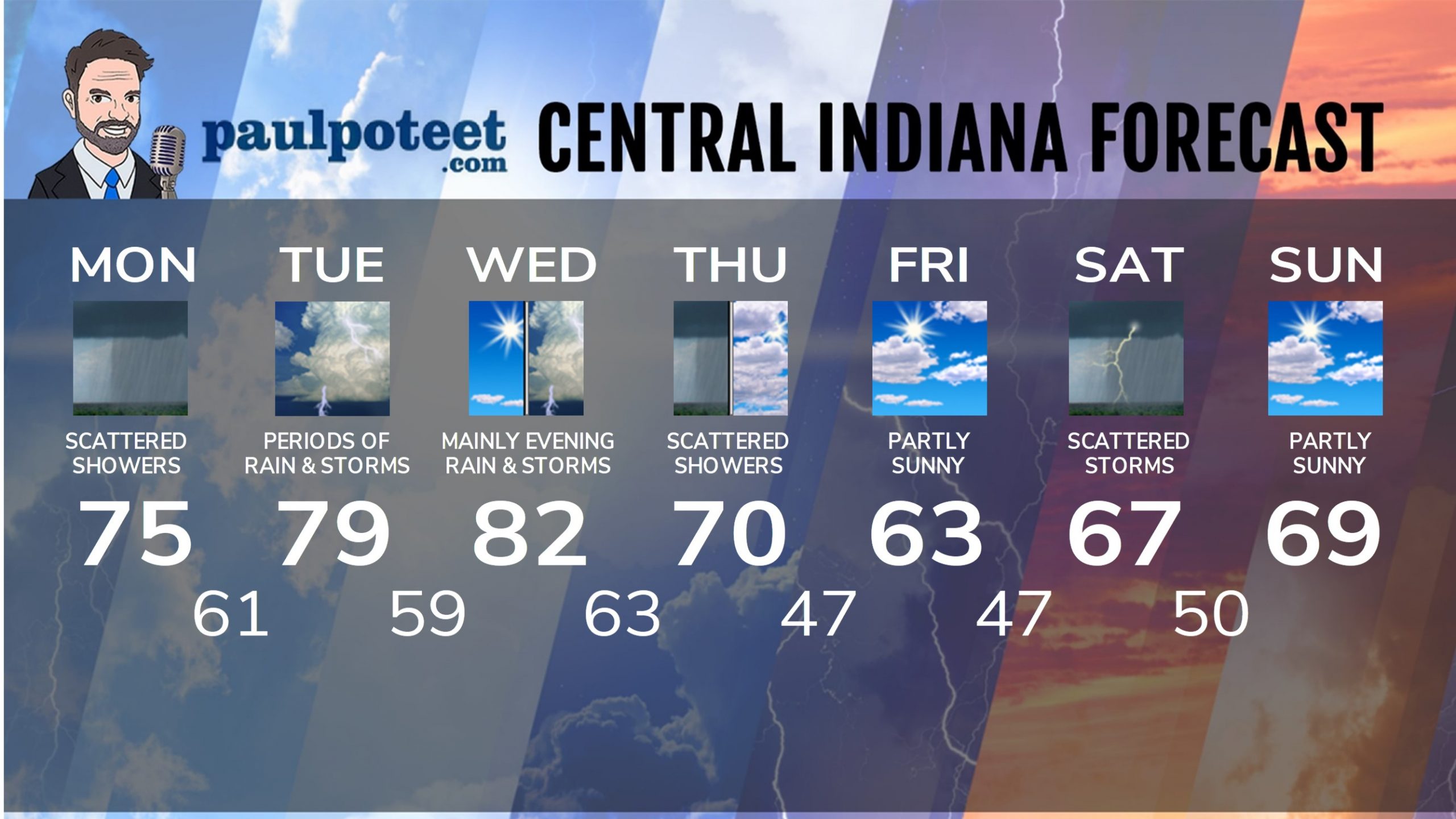
INDY SEVEN DAY FORECAST
Today: Cloudy, with scattered showers. High 75.
Tonight: Early evening shower chance, then some clearing. Low 61.
Tuesday: Partly to mostly cloudy. Showers and storms, mainly in the morning. Another round later in the mid to late afternoon. Some storms could be severe in the afternoon. High 79.
Tuesday Night: Evening showers and storms could be severe. Clearing after midnight. Low 59.
Wednesday: Mostly sunny to partly sunny. High 82.
Wednesday Night: Showers and storms, possibly severe. Low 63.
Thursday: Partly to mostly cloudy, with scattered showers. High 70.
Thursday Night: Partly cloudy. Low 47.
Friday: Partly sunny. High 63.
Friday Night: Partly cloudy. Low 47.
Saturday: Mostly cloudy with scattered showers and storms. High 67.
Saturday Night: Partly cloudy. Low 50.
Sunday: Partly sunny. High 69.


Never miss me! Subscribe for free. My Huge Radar has real-time weather tracking, current temperatures, and severe weather watches and warnings. Get detailed Indiana conditions by clicking here. Click here to see my central Indiana 7-Day Forecast. Follow these links to get my forecasts for Lafayette, Muncie, Hendricks County, and Hamilton County. Need a second opinion? Click here for central Indiana National Weather Service forecasts. (Some charts via WeatherBELL.)


Leave a Reply