…Preliminary NWS Damage Survey for March 14, 2024 Tornado Event
Update #2…
.Update…Second update to include more detailed information of
the tornado through the towns of Selma and Winchester.
.Overview…Multiple intense supercells impacted the north-central
and northeastern portions of central Indiana during the late
afternoon and evening of Thursday, March 14, 2024. The storms
produced multiple reports of large to very large hail, and one long-
track tornado across eastern Delaware and Randolph counties.
This tornado continued beyond the listed end point below at the
state line into western Ohio (information about the tornado in
western Ohio will be available from NWS Wilmington OH).
The statistics below show preliminary results from the NWS
Indianapolis Survey Team across eastern Delaware and Randolph
counties. Relevant data will continue to be reviewed by NWS
meteorologists in the coming days.
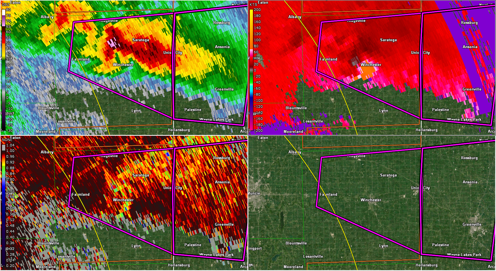
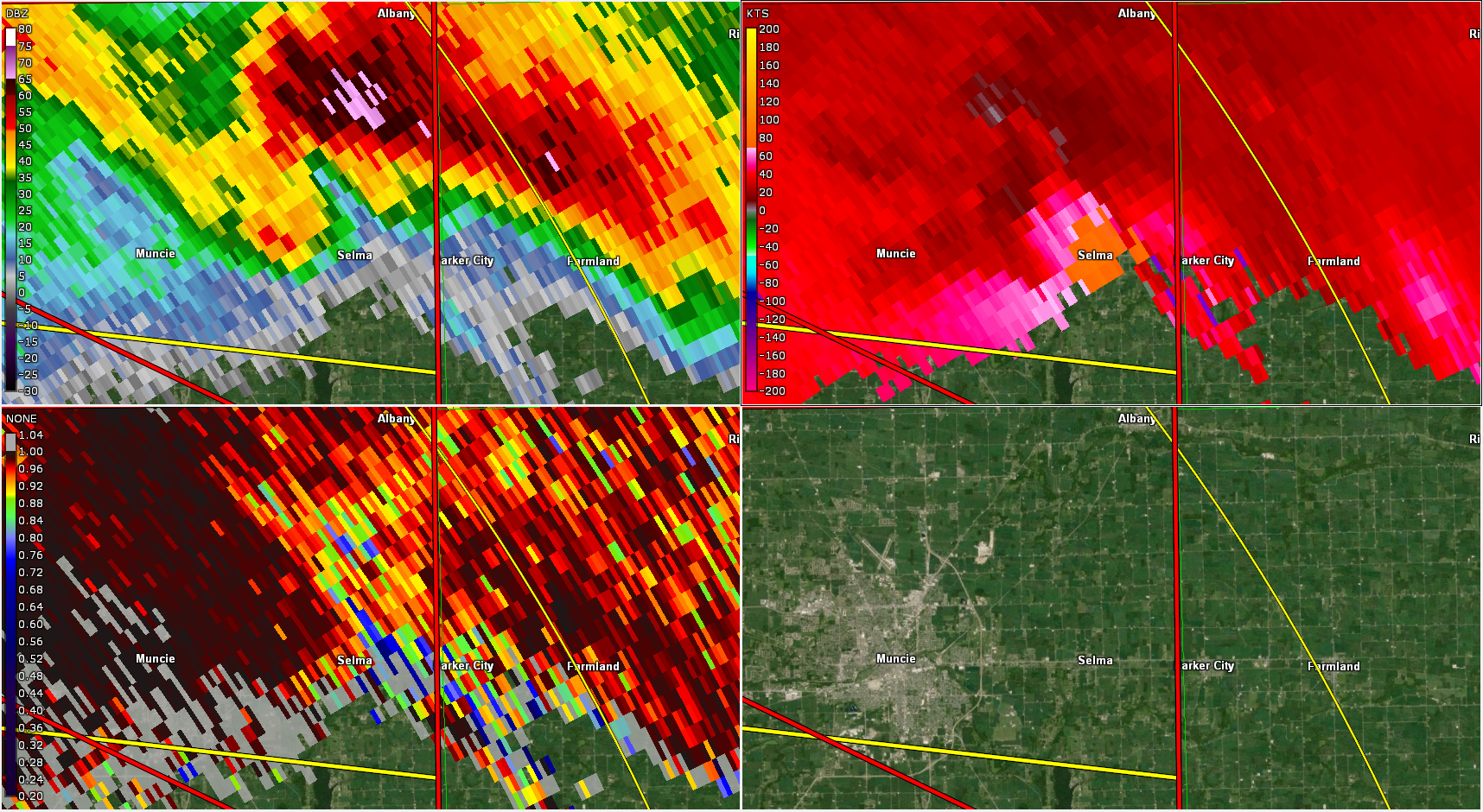
The tornado started northwest of Selma near Truitt Rd damaging roofs
on homes. It then moved east southeast through Selma damaging a
number of homes, uprooting and snapping trees, and knocking over
some utility poles. Highest wind intensity in Selma, indicated by
extensive damage to a couple homes, was estimated at 120-130 mph, or
EF2 on the Enhanced Fujita Scale. Maximum path width through Selma
was about 200-300 yards.
The tornado continued though an open area and fields between Selma
and Winchester, bending or snapping numerous utility poles along
State Road 32. Also, a large blade on one of the wind turbines in
the area was badly damaged.
As the tornado entered Winchester, it severely damaged many homes
and snapped and uprooted trees in a west-to-east path through
Winchester. There was clear evidence of the tornado’s rotational
circulation, with uprooted trees pointed to the east on the
immediate south side of the tornado, and to the northwest on the
immediate north side of the tornado. The damage pattern also
indicated the possibility of small multiple vortices rotating around
the main vortex. In the residential core of the town, the maximum
intensity of the tornado was estimated around 130 mph or high-end
EF2 strength.
The greatest damage in Winchester occurred on the east side of town
at the Taco Bell, as the anchored building was destroyed, as was a
church immediately east of the restaurant. In this concentrated
area, the NWS Team estimated maximum winds of 155-165 mph, or high-
end EF3 damage. Maximum path width in Winchester was estimated at up
to 0.4 mile or 700 yards.
Farther east across more rural eastern Randolph County, a few
structures had significant damage, debris was blown in fields, many
trees were snapped, and a silo was damaged, all indicative of EF2
maximum damage in the 115-125 mph range.
The tornado continued to the Indiana-Ohio state line, with
less intense damage primarily to trees before crossing into Ohio.
The NWS Indianapolis Survey Team greatly appreciates the help of
Indiana State Police Officer Dave Poynter who escorted our team
through the damage in Winchester and points east!
.Selma Winchester Tornado…
Rating: EF3
Estimated Peak Wind: 155-165 mph
Path Length /statute/: 25.03 miles
Path Width /maximum/: 700 yards
Fatalities: 0
Injuries: 38
Start Date: 03/14/2024
Start Time: 07:37 PM EDT
Start Location: Selma / Delaware County / IN
Start Lat/Lon: 40.1947 / -85.2793
End Date: 03/14/2024
End Time: 08:13 PM EDT
End Location: 2 SSW Union City / Randolph County / OH
End Lat/Lon: 40.1715 / -84.8094
&&
EF Scale: The Enhanced Fujita Scale classifies tornadoes into the
following categories:
EF0…..65 to 85 mph
EF1…..86 to 110 mph
EF2…..111 to 135 mph
EF3…..136 to 165 mph
EF4…..166 to 200 mph
EF5…..>200 mph
Click here for more information, including damage reports from wind and hail. Doppler radar snapshots below. Click to enlarge.
Never miss me! Subscribe for free. My Huge Radar has real-time weather tracking, current temperatures, and severe weather watches and warnings. Get detailed Indiana conditions by clicking here. Click here to see my central Indiana 7-Day Forecast. Follow these links to get my forecasts for Lafayette, Muncie, Hendricks County, and Hamilton County. Need a second opinion? Click here for central Indiana National Weather Service forecasts. (Some charts via WeatherBELL.)


