Expect travel disruptions Wednesday as 4-8 inches of snow accumulates. South of Indy there could be rain mixing with the snow, keeping totals between 3-6 inches. 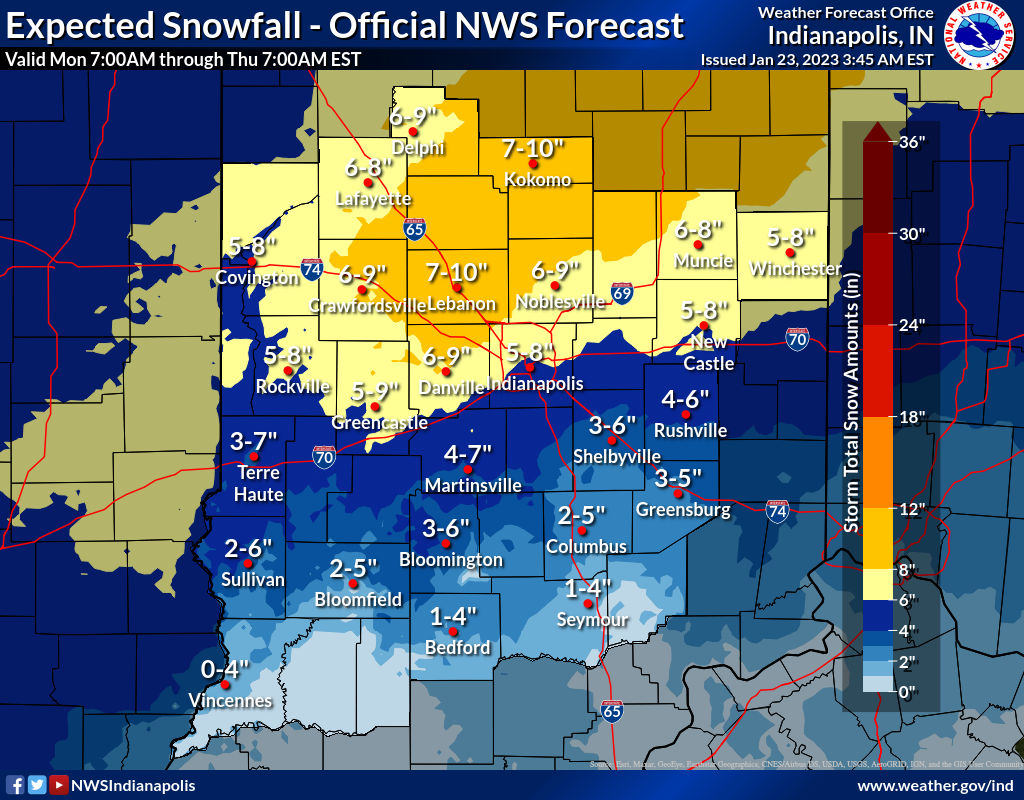 The snow will start between midnight and 6am Wednesday, and last through the day. It will diminish by evening.
Never miss me! Subscribe for free. My Huge Radar has real-time weather tracking, current temperatures, and severe weather watches and warnings. Get detailed Indiana conditions by clicking here. Click here to see my central Indiana 7-Day Forecast. Follow these links to get my forecasts for Lafayette, Muncie, Hendricks County, and Hamilton County. Need a second opinion? Click here for central Indiana National Weather Service forecasts. (Some charts via WeatherBELL.)
INDY SEVEN DAY FORECAST
Today: Cloudy, with peaks of afternoon sunshine possible. High 35.
Tonight: Partly cloudy evening. Mostly cloudy overnight. Low 29.
Tuesday: Mostly cloudy. High 40.
Tuesday Night: Snow after midnight. Low 32.
Wednesday: Snow, heavy at times. Wind gusting to 30 mph. High 34.
Wednesday Night: Snow dminishes. Final totals of 4-8 inches. Low 28.
Thursday: Mostly cloudy. A few snow showers. High 31.
Thursday Night: Mostly cloudy. Low 23.
Friday: Mostly cloudy. High 35.
Friday Night: Mostly cloudy. Low 32.
Saturday: Mostly cloudy. High 38.
Saturday Night: Wintry mix and rain and freezing rain possible late. Low 31.
Sunday: Patchy showers of rain, snow, and freezing rain all possible. High 36.

Never miss me! Subscribe for free. My Huge Radar has real-time weather tracking, current temperatures, and severe weather watches and warnings. Get detailed Indiana conditions by clicking here. Click here to see my central Indiana 7-Day Forecast. Follow these links to get my forecasts for Lafayette, Muncie, Hendricks County, and Hamilton County. Need a second opinion? Click here for central Indiana National Weather Service forecasts. (Some charts via WeatherBELL.)


