Morning fog north of Indy gives way to sunshine. A strong cold front arrives late Sunday, with wind and rain. A dusting of snow is on the table for next week!
Never miss me! Subscribe for free. My Huge Radar has real-time weather tracking, current temperatures, and severe weather watches and warnings. Get detailed Indiana conditions by clicking here. Click here to see my central Indiana 7-Day Forecast. Follow these links to get my forecasts for Lafayette, Muncie, Hendricks County, and Hamilton County. Need a second opinion? Click here for central Indiana National Weather Service forecasts. (Some charts via WeatherBELL.)
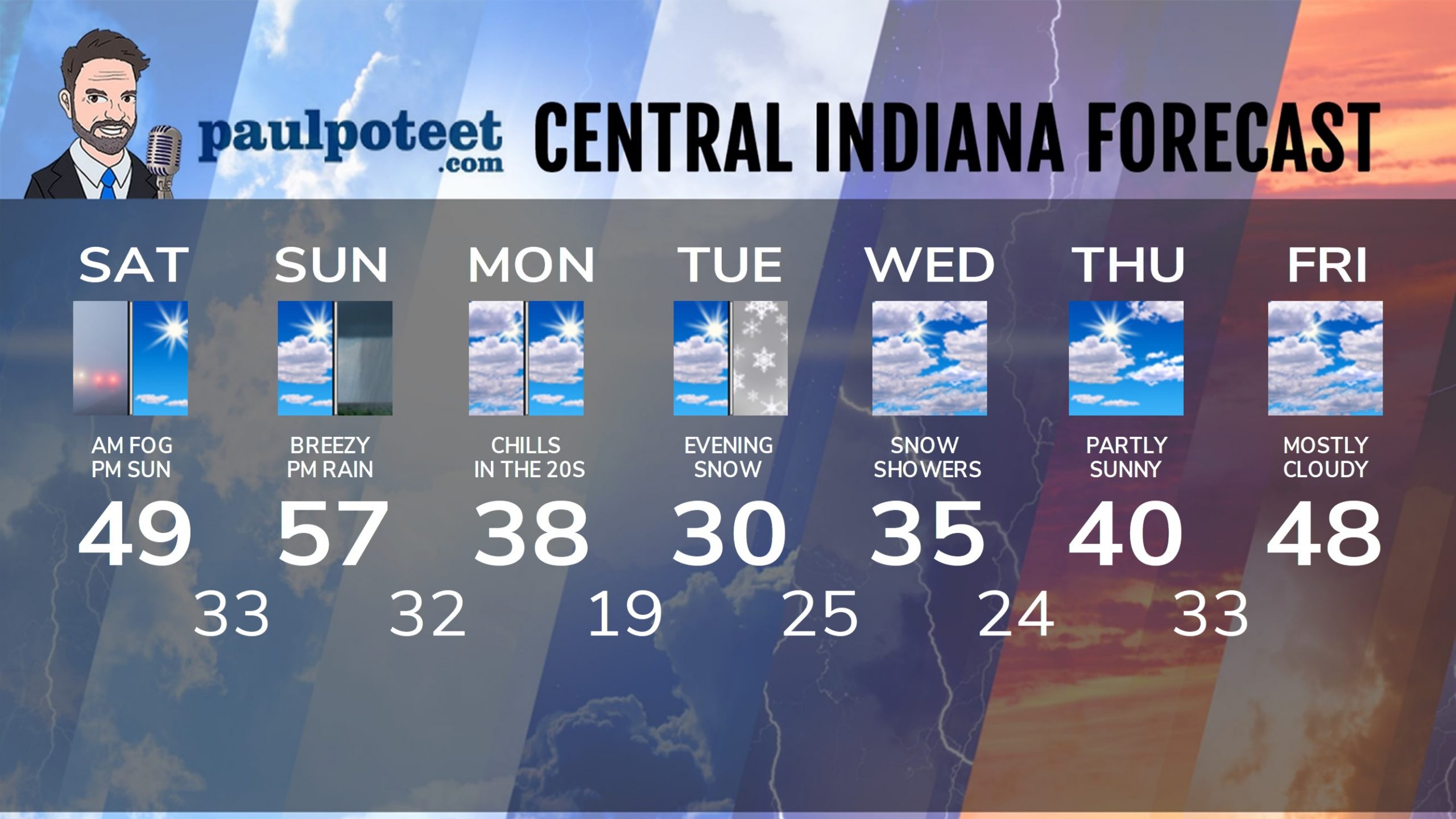
INDY SEVEN DAY FORECAST
Today: Morning fog north and northeast of Indy gives way to sunshine. High 49.
Tonight: Mostly clear. Low 33.
Sunday: Partly sunny morning. Scattered showers in the afternoon. Wind gusting to 25 mph. High 57 in the evening.
Sunday Night: Rainy and windy, with gusts to 30 mph. Some thunder possible. Low 32.
Monday: Partly sunny, and colder again. Wind gusting to 30 mph. Chills in the teens and 20s. High 38.
Monday Night: Clouds increase. Chills in the teens. Low 19.
Tuesday: Partly to mostly cloudy. Chills in the 20s. High 30.
Tuesday Night: Snow showers, with a dusting possible. Low 25.
Wednesday: Mostly cloudy. Snow showers possible. High 35.
Wednesday Night: Mostly cloudy. Snow showers possible. Low 24.
Thursday: Partly sunny. High 40.
Thursday Night; Partly cloudy. Low 33.
Friday: Mostly cloudy. High 48.
Never miss me! Subscribe for free. My Huge Radar has real-time weather tracking, current temperatures, and severe weather watches and warnings. Get detailed Indiana conditions by clicking here. Click here to see my central Indiana 7-Day Forecast. Follow these links to get my forecasts for Lafayette, Muncie, Hendricks County, and Hamilton County. Need a second opinion? Click here for central Indiana National Weather Service forecasts. (Some charts via WeatherBELL.)


