Today’s the last full day of Winter, and Mother Nature is full of it. I suppose that’s payback for March so far, which has been ten degrees above average officially in Indianapolis. The season-to-date snow total is locked at 8.2 inches, and unlikely to change any time soon, despite the prospect of snow showers and flurries today. The normal, by the way, would be 24.3 inches by this point. Precipitation is not a problem. That number is almost an inch above average. Just light amounts for us over the next week, mainly Friday.
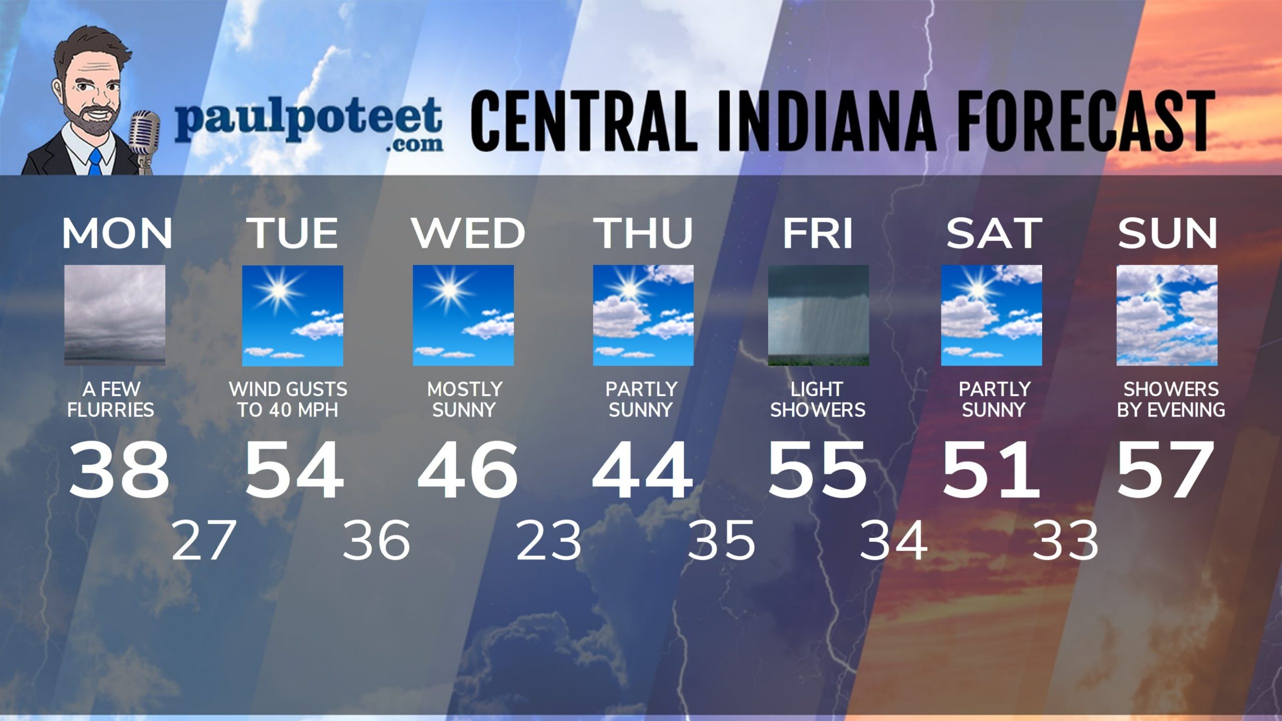
INDY SEVEN DAY FORECAST
Today: Mostly cloudy and colder, with a few flurries. Chills in the teens during morning drive, and 20s.the rest of the day. High 38.
Tonight: Cloudy evening. Clouds decrease after midnight, with chills in the teens. Low 27.
Tuesday: Mostly sunny, with wind gusts to 40 mph. Chills in the teens and 20s in the morning. High 54.
Tuesday Night: Mostly clear. Low 36.
Wednesday: Mostly sunny. High 46.
Wednesday Night: Clear. Low 23.
Thursday: Partly sunny. High 44.
Thursday Night: Clouds increase. Low 35.
Friday: Scattered light showers. High 55.
Friday Night: Scattered showers. Low 34.
Saturday: Partly sunny. High 51.
Saturday Night: Partly cloudy. Low 33.
Sunday: Mostly cloudy, with shower chances by evening. High 57.
Never miss me! Subscribe for free. My Huge Radar has real-time weather tracking, current temperatures, and severe weather watches and warnings. Get detailed Indiana conditions by clicking here. Click here to see my central Indiana 7-Day Forecast. Follow these links to get my forecasts for Lafayette, Muncie, Hendricks County, and Hamilton County. Need a second opinion? Click here for central Indiana National Weather Service forecasts. (Some charts via WeatherBELL.)


