The count of tornadoes from Friday across Indiana is now up to 21. Here are links to summaries from three Weather Service offices.
Chicago (for tornadoes in NW Indiana.)
Unfortunately there is another threat for severe weather with the arrival of a cold front Wednesday. The prime time for trouble will be in the afternoon.

Never miss me! Subscribe for free. My Huge Radar has real-time weather tracking, current temperatures, and severe weather watches and warnings. Get detailed Indiana conditions by clicking here. Click here to see my central Indiana 7-Day Forecast. Follow these links to get my forecasts for Lafayette, Muncie, Hendricks County, and Hamilton County. Need a second opinion? Click here for central Indiana National Weather Service forecasts. (Some charts via WeatherBELL.)
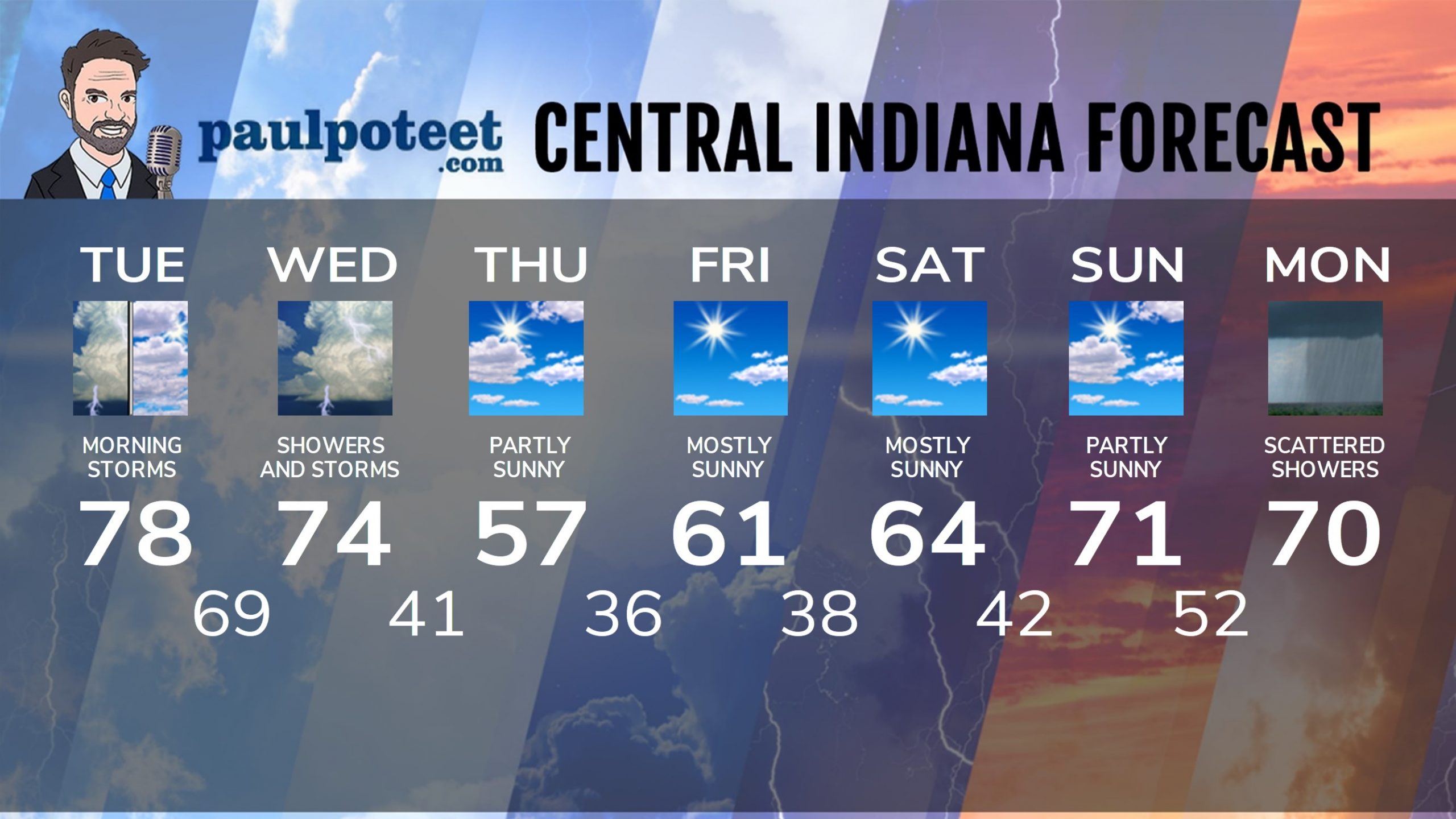
INDY SEVEN DAY FORECAST
Today: Spotty morning showers and storms, then mostly to partly cloudy. High 78.
Tonight: Partly to mostly cloudy evening. Spotty showers and storms after midnight. Low 69.
Wednesday: Showers and storms. A few storms could be severe. High 74.
Wednesday Night: Partly cloudy. Low 41.
Thursday: Partly sunny. High 57.
Thursday Night: Partly cloudy. Low 36.
Friday: Mostly sunny. High 61.
Friday Night: Mostly clear. Low 38.
Saturday: Mostly sunny. High 64.
Saturday Night: Partly cloudy. Low 42.
Sunday: Partly sunny. High 71.
Sunday Night: Partly cloudy. Scattered showers after midnight. Low 52.
Monday: Mostly cloudy, with scattered showers. High 70.
Never miss me! Subscribe for free. My Huge Radar has real-time weather tracking, current temperatures, and severe weather watches and warnings. Get detailed Indiana conditions by clicking here. Click here to see my central Indiana 7-Day Forecast. Follow these links to get my forecasts for Lafayette, Muncie, Hendricks County, and Hamilton County. Need a second opinion? Click here for central Indiana National Weather Service forecasts. (Some charts via WeatherBELL.)


