Mother Nature’s gonna pay us back this weekend, as the big breezes and rainfall of Thursday gives way to sunny days!
Those big breezes brought big temperatures. It was the warmest day since January 3 in Indianapolis, where the high was 60. It was also 60 in Terre Haute. The high was 62 in Muncie, Bloomington, and Shelbyville. It was 57 in Lafayette.
THURSDAY’S WICKED WINDS:
..SELECT PEAK WIND REPORTS ACROSS CENTRAL INDIANA...

LOCATION                     SPEED     TIME/DATE       LAT/LON
FRANKFORT                    57 MPH    0430 PM 02/09   40.26N/86.66W
0.8 N CLOVERDALE (INDOT)     57 MPH    0349 PM 02/09   39.53N/86.80W
BLOOMINGTON                  56 MPH    1235 PM 02/09   39.14N/86.57W
WESTFIELD                    55 MPH    0922 AM 02/09   40.01N/86.18W
3.3 N LEWISVILLE (INDOT)     55 MPH    0549 PM 02/09   39.85N/85.35W
SHELBYVILLE                  55 MPH    0428 PM 02/09   39.58N/85.80W
FELDUN PURDUE AGRICULTURAL C 55 MPH    0800 AM 02/09   38.89N/86.56W
1.5 NE WHITEHALL (INDOT)     54 MPH    0400 PM 02/09   39.19N/86.56W
INDIANAPOLIS                 54 MPH    0340 PM 02/09   39.72N/86.30W
GEORGETOWN ROAD OVER I-65    53 MPH    1250 PM 02/09   39.84N/86.24W
BLOOMINGTON                  53 MPH    0759 AM 02/09   39.15N/86.62W
W. LAFAYETTE - PURDUE UNIV.  53 MPH    0328 PM 02/09   40.42N/86.93W
MUNCIE                       53 MPH    0101 PM 02/09   40.23N/85.40W
KOKOMO                       53 MPH    0509 PM 02/09   40.53N/86.07W
EDINBURGH                    52 MPH    0148 PM 02/09   39.36N/85.91W
MARKET ST. TO I65 & I70      52 MPH    0859 AM 02/09   39.77N/86.14W
INDIANAPOLIS REG             52 MPH    0935 AM 02/09   39.85N/85.90W
INDIANAPOLIS EXC             52 MPH    0855 AM 02/09   40.03N/86.25W
NEW PALESTINE                51 MPH    0515 PM 02/09   39.70N/85.88
Never miss me! Subscribe for free. My Huge Radar has real-time weather tracking, current temperatures, and severe weather watches and warnings. Get detailed Indiana conditions by clicking here. Click here to see my central Indiana 7-Day Forecast. Follow these links to get my forecasts for Lafayette, Muncie, Hendricks County, and Hamilton County. Need a second opinion? Click here for central Indiana National Weather Service forecasts. (Some charts via WeatherBELL.)
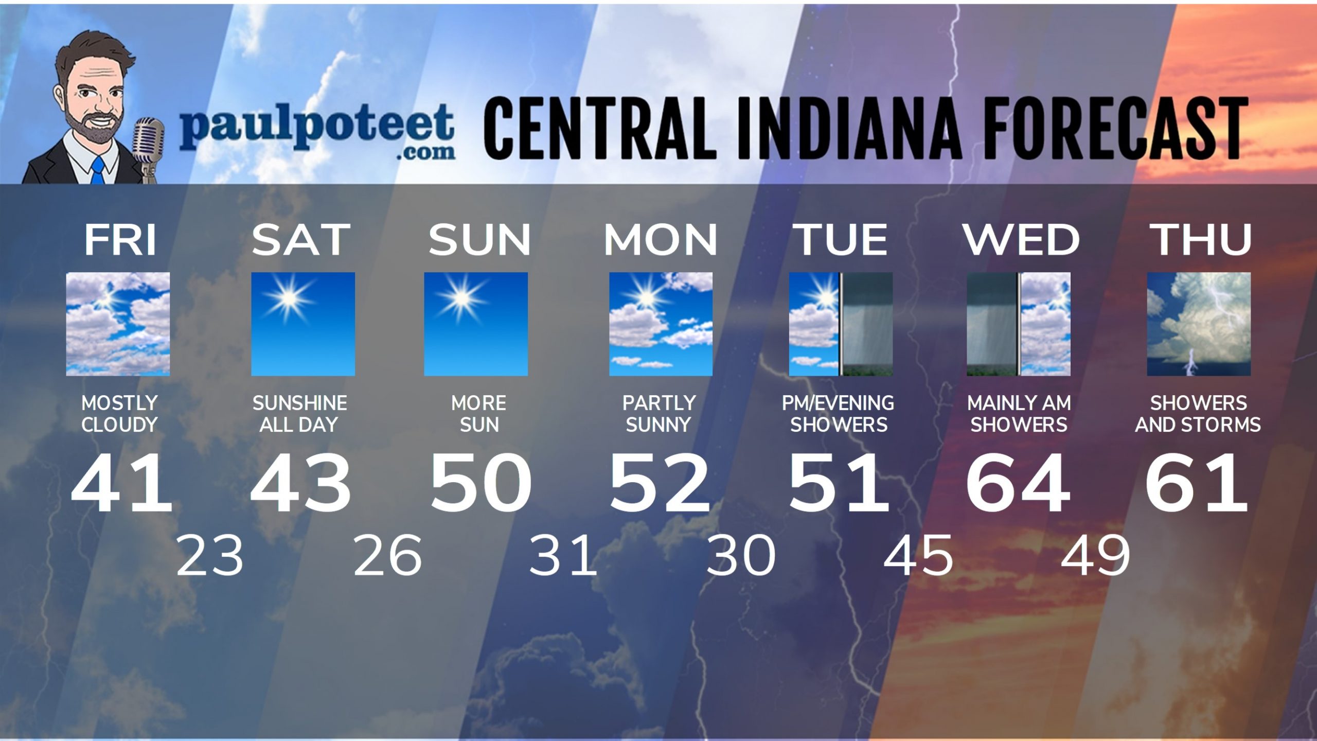
INDY SEVEN DAY FORECAST
Friday: Mostly cloudy. High 41.
Friday Night: Partly cloudy. Low 23.
Saturday: Sunny. High 43.
Saturday Night: Mostly clear. Low 26.
Sunday: Sunny. High 50.
Sunday Night: Partly cloudy. Low 31.
Monday: Partly sunny. High 52.
Monday Night: Partly cloudy. Low 30.
Tuesday: Partly to mostly cloudy, with scattered afternoon showers. High 51.
Tuesday Night: Scattered showers. Low 45.
Wednesday: Scattered showers, mainly in the morning. High 64.
Wednesday Night: Scattered showers after midnight. Low 49.
Thursday: Showers likely. Storms possible. High 61.
Never miss me! Subscribe for free. My Huge Radar has real-time weather tracking, current temperatures, and severe weather watches and warnings. Get detailed Indiana conditions by clicking here. Click here to see my central Indiana 7-Day Forecast. Follow these links to get my forecasts for Lafayette, Muncie, Hendricks County, and Hamilton County. Need a second opinion? Click here for central Indiana National Weather Service forecasts. (Some charts via WeatherBELL.)


