It’s Deja vu all over again, with another mild January week that turns colder on Friday into the weekend. This time it appears the heat stays off for awhile.
Peak wind gusts Thursday:
51 mph Muncie
48 mph Indianapolis
44 mph Lafayette
42 mph Bloomington
And how ’bout that heat! The high temps on Thursday were 57 in Muncie and Bloomington. It was 56 in Indy, and 47 in Lafayette.
Looking ahead, we might get around an inch of snow Sunday, mainly in the morning. The potential is there for moderate snow Wednesday, winter fans!
Never miss me! Subscribe for free. My Huge Radar has real-time weather tracking, current temperatures, and severe weather watches and warnings. Get detailed Indiana conditions by clicking here. Click here to see my central Indiana 7-Day Forecast. Follow these links to get my forecasts for Lafayette, Muncie, Hendricks County, and Hamilton County. Need a second opinion? Click here for central Indiana National Weather Service forecasts. (Some charts via WeatherBELL.)
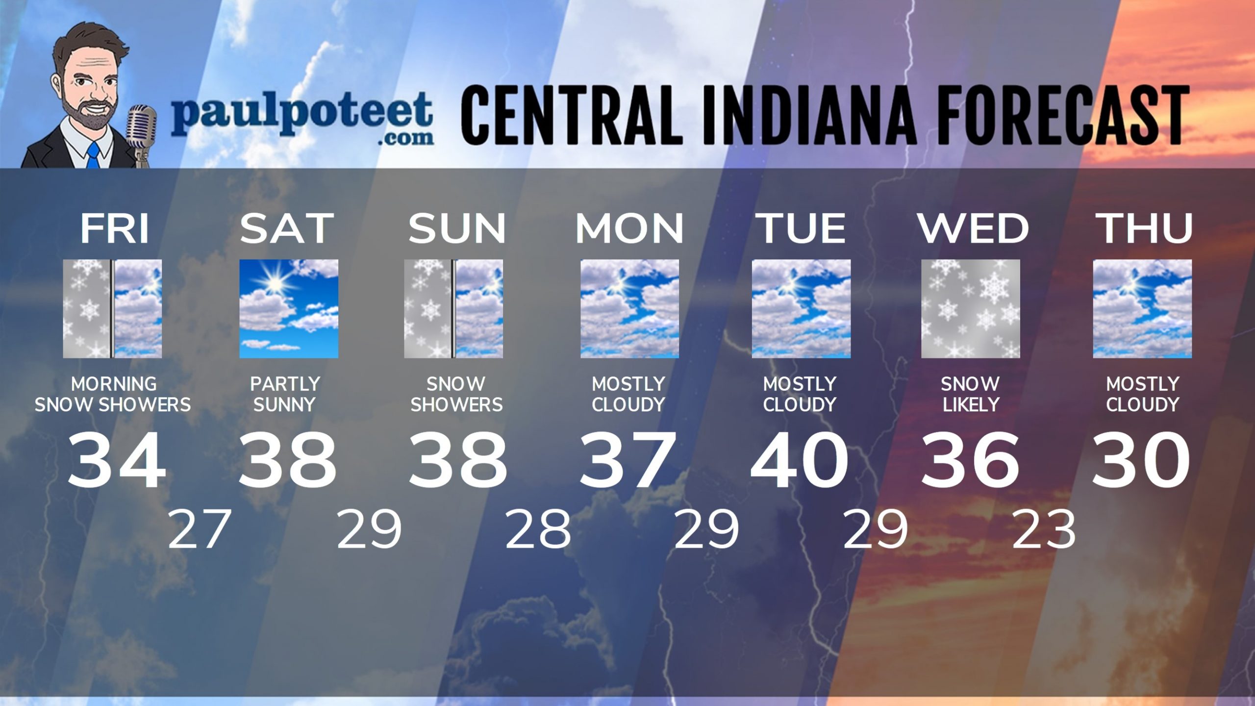
INDY SEVEN DAY FORECAST
Friday: Cloudy to mostly cloudy. A few snow showers, mainly in the morning. High 34.
Friday Night: Mostly cloudy evening, with a few flurries. Partly cloudy overnight. Low 27.
Saturday: Partly sunny. High 38.
Saturday Night: Clouds increase. Snow showers toward daybreak. Low 29.
Sunday: Mostly cloudy. Snow showers. Little or no accumulation. High 38.
Sunday Night: Mostly cloudy. Low 28.
Monday: Mostly cloudy. High 37.
Monday Night: Mostly cloudy. Low 29.
Tuesday: Mostly cloudy. High 40.
Tuesday Night: Rain, and then snow showers. Low 29.
Wednesday: Periods of snow. Some accumulation. High 36.
Wednesday Night: Mostly cloudy. Low 23.
Thursday: Mostly cloudy. High 30.
Never miss me! Subscribe for free. My Huge Radar has real-time weather tracking, current temperatures, and severe weather watches and warnings. Get detailed Indiana conditions by clicking here. Click here to see my central Indiana 7-Day Forecast. Follow these links to get my forecasts for Lafayette, Muncie, Hendricks County, and Hamilton County. Need a second opinion? Click here for central Indiana National Weather Service forecasts. (Some charts via WeatherBELL.)


