Clouds once again determined low temperatures this morning. They cleared more around Lafayette, where the low dropped to 30. It was even freezin’ in Indianapolis and Terre Haute. The low was 33 in Kokomo, 34 in Anderson, but 37 in Muncie, where clouds held on the longest.
Even colder tonight, with a mostly clear sky and a Freeze Warning for all of central Indiana, from midnight until 10am Thursday.
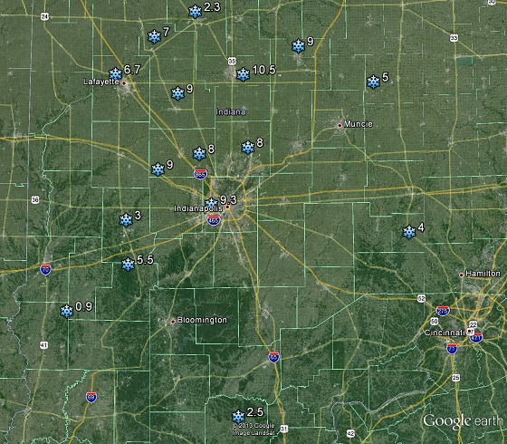
On this date 33 years ago…there was a big blanket of snow on the ground in central Indiana. The record for earliest snowfall at Indianapolis was set on October 18, 1989 with 0.2 inch. (The average date of the first measurable snowfall at Indianapolis is November 19). This was the first of 3 consecutive days of measurable snowfall from a potent storm system. The total for the storm at Indianapolis was 9.3 inches, with an even higher total at Kokomo with 10.5 inches from the storm. Click here for a complete National Weather Service summary.
Never miss me! Subscribe for free. My Huge Radar has real-time weather tracking, current temperatures, and severe weather watches and warnings. Get detailed Indiana conditions by clicking here. Click here to see my central Indiana 7-Day Forecast. Follow these links to get my forecasts for Lafayette, Muncie, Hendricks County, and Hamilton County. Need a second opinion? Click here for central Indiana National Weather Service forecasts. (Some charts via WeatherBELL.)
INDY SEVEN DAY FORECAST
Today: Becoming mostly sunny. Wind gusts to 25 mph. FREEZE WARNING until 10am. High 51.
Tonight: Mostly clear to partly cloudy, and even colder. Wind gusts to 20 mph. Low 30.
Thursday: Mostly sunny. Wind gusting to 30 mph. High 59.
Thursday Night: Partly cloudy and not as cold. Low 40.
Friday: Mostly sunny, with just high thin clouds. High 70.
Friday Night: Mostly clear. Low 50.
Saturday: Mostly sunny, with just high thin clouds. High 74.
Saturday Night: Mostly clear. Low 52.
Sunday: Sunny! High 75.
Sunday Night: Partly cloudy. Low 56.
Monday: Partly sunny. Spotty afternoon showers. High 75.
Monday Night: Scattered showers. Low 53.
Tuesday: Showers likely. High 68.

Never miss me! Subscribe for free. My Huge Radar has real-time weather tracking, current temperatures, and severe weather watches and warnings. Get detailed Indiana conditions by clicking here. Click here to see my central Indiana 7-Day Forecast. Follow these links to get my forecasts for Lafayette, Muncie, Hendricks County, and Hamilton County. Need a second opinion? Click here for central Indiana National Weather Service forecasts. (Some charts via WeatherBELL.)


