Two big stories over the next two days. Today’s is temperatures. The afternoon heat index numbers are going to flirt with triple digits. Two charts for the two stories. This first one shows all the feels (like) numbers for Wednesday afternoon. One mitigating factor this afternoon: wind gusts to 30 mph may help take the sweat off your brow.
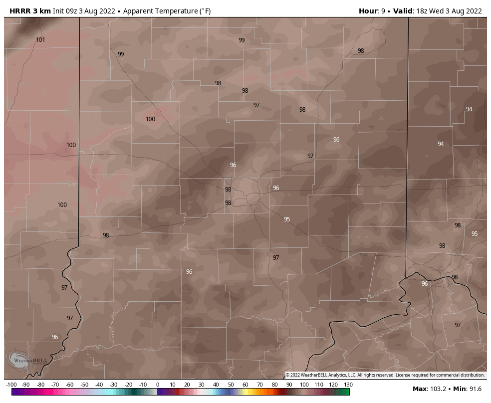
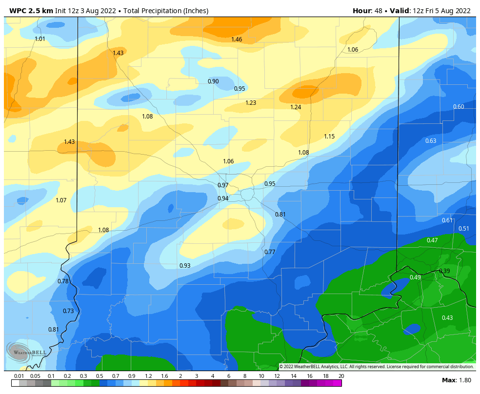
Chart number two shows potential rainfall through Friday. The bulk will come later Wednesday evening into Thursday. We need it!
At the moment severe weather looks unlikely in central Indiana through the weekend.
Never miss me! Subscribe for free. My Huge Radar has real-time weather tracking, current temperatures, and severe weather watches and warnings. Get detailed Indiana conditions by clicking here. Click here to see my central Indiana 7-Day Forecast. Follow these links to get my forecasts for Lafayette, Muncie, Hendricks County, and Hamilton County. Need a second opinion? Click here for central Indiana National Weather Service forecasts. (Some charts via WeatherBELL.)
INDY SEVEN DAY FORECAST
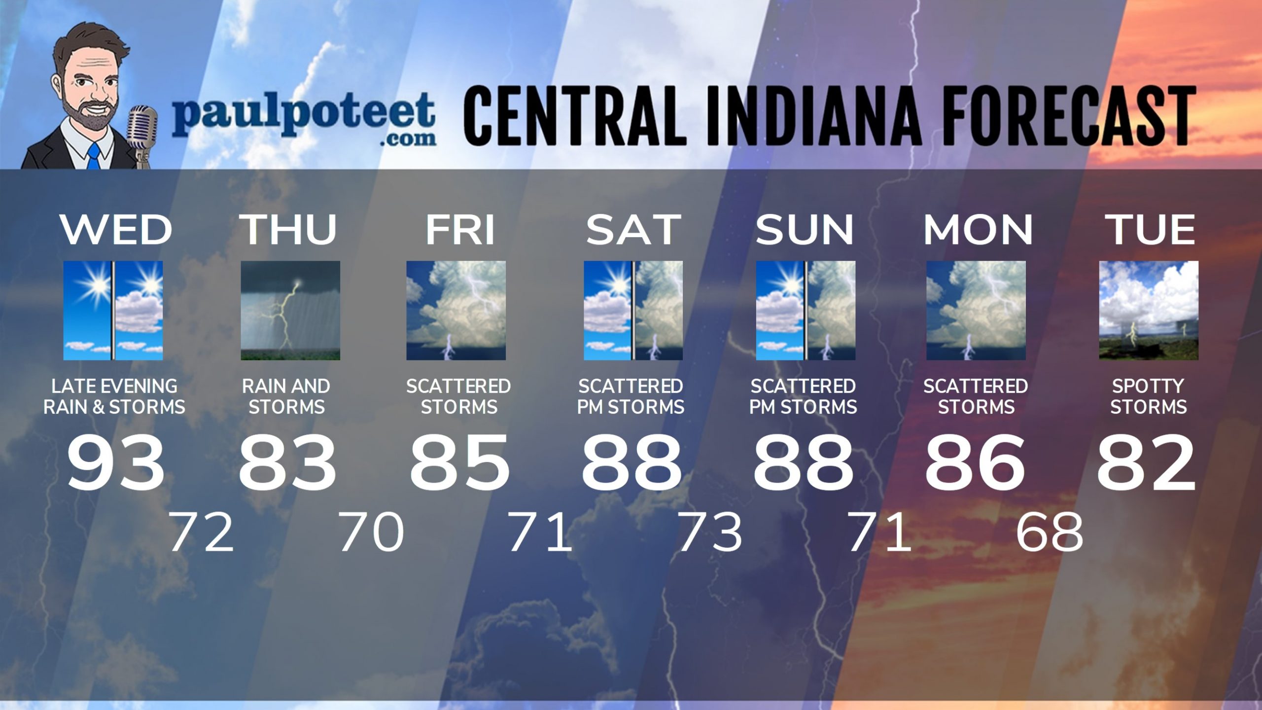
Today: Mostly to partly sunny, hot and humid. High 93.
Tonight: Showers and storms after sunset. Low 72.
Thursday: Rain in the morning. Rain and some thunder in the afternoon. High 83.
Thursday Night: Scattered showers and storms. Low 70.
Friday: Partly to mostly cloudy. Scattered showers and storms. High 85.
Friday Night: Partly cloudy, with scattered showers and storms. Low 71.
Saturday: Partly sunny. Scattered showers and storms in the afternoon. High 88.
Saturday Night: Partly cloudy. Low 73.
Sunday: Partly sunny. Scattered showers and storms in the afternoon. High 88.
Sunday Night: Scattered showers and storms. Low 71.
Monday: Scattered showers and storms. High 86.
Monday Night: Scattered showers and storms. Low 68.
Tuesday: Partly sunny. Spotty showers and storms. High 82.
Never miss me! Subscribe for free. My Huge Radar has real-time weather tracking, current temperatures, and severe weather watches and warnings. Get detailed Indiana conditions by clicking here. Click here to see my central Indiana 7-Day Forecast. Follow these links to get my forecasts for Lafayette, Muncie, Hendricks County, and Hamilton County. Need a second opinion? Click here for central Indiana National Weather Service forecasts. (Some charts via WeatherBELL.)


