Little if any rain for most in the wake of an early morning cold front. It may not show up on your sidewalk, but the front’s effects do show up on the morning visible satellite picture. Look to the south/southeast of Indianapolis.

Never miss me! Subscribe for free. My Huge Radar has real-time weather tracking, current temperatures, and severe weather watches and warnings. Get detailed Indiana conditions by clicking here. Click here to see my central Indiana 7-Day Forecast. Follow these links to get my forecasts for Lafayette, Muncie, Hendricks County, and Hamilton County. Need a second opinion? Click here for central Indiana National Weather Service forecasts. (Some charts via WeatherBELL.)
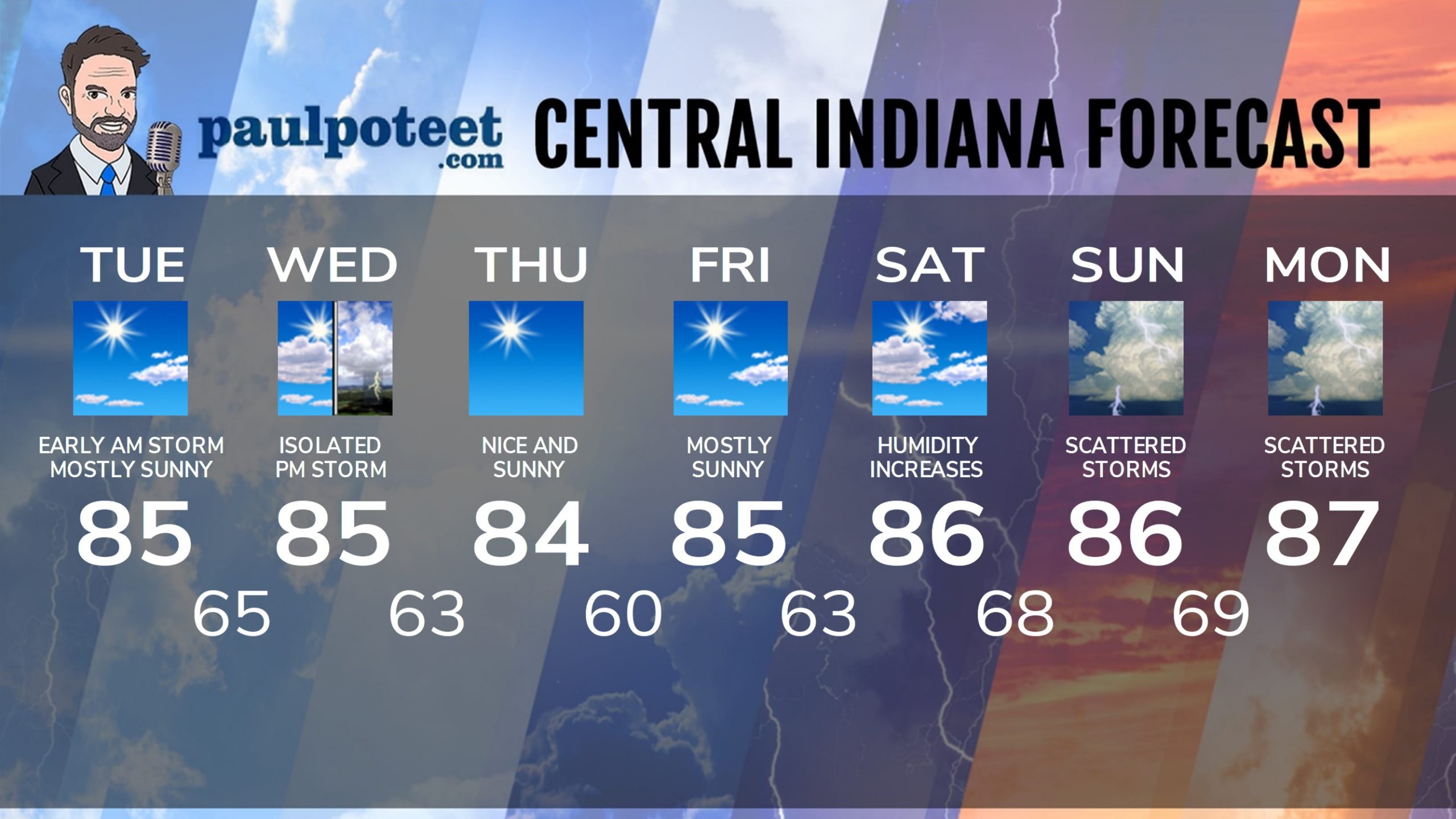
INDY SEVEN DAY FORECAST
Today: Early morning lingering shower or storm, then mostly sunny. Humidity decreases. High 85.
Tonight: Mostly clear. Low 65.
Wednesday: Mostly sunny morning. Partly sunny afternoon, with an isolated shower or storm. High 85.
Wednesday Night: Clearing and cooler. Low 63.
Thursday: Nice and sunny. High 84.
Thursday Night: Clear. Low 60.
Friday: Mostly sunny. High 85.
Friday Night: Partly cloudy. Low 63.
Saturday: Partly sunny. Humidity increases. High 86.
Saturday Night: Partly cloudy. Scattered storms late. Low 68.
Sunday: Partly to mostly cloudy, with scattered showers and storms. High 86.
Saturday Night: Partly to mostly cloudy, with scattered showers and storms. Low 69.
Monday: Partly to mostly cloudy, with scattered showers and storms. High 87.
Never miss me! Subscribe for free. My Huge Radar has real-time weather tracking, current temperatures, and severe weather watches and warnings. Get detailed Indiana conditions by clicking here. Click here to see my central Indiana 7-Day Forecast. Follow these links to get my forecasts for Lafayette, Muncie, Hendricks County, and Hamilton County. Need a second opinion? Click here for central Indiana National Weather Service forecasts. (Some charts via WeatherBELL.)


