Ma Nature’s been busy this week, bringing Texas twisters Monday, and springing a killer tornado on New Orleans last night. No outbreaks expected here today, but there is a marginal (level 1 of 5) risk of severe weather for much of central Indiana, and a slight (level 2 of 5) risk around Muncie and New Castle.

Never miss me! Subscribe for free. My Huge Radar has real-time weather tracking, current temperatures, and severe weather watches and warnings. Get detailed Indiana conditions by clicking here. Click here to see my central Indiana 7-Day Forecast. Follow these links to get my forecasts for Lafayette, Muncie, Hendricks County, and Hamilton County. Need a second opinion? Click here for central Indiana National Weather Service forecasts. (Some charts via WeatherBELL.)
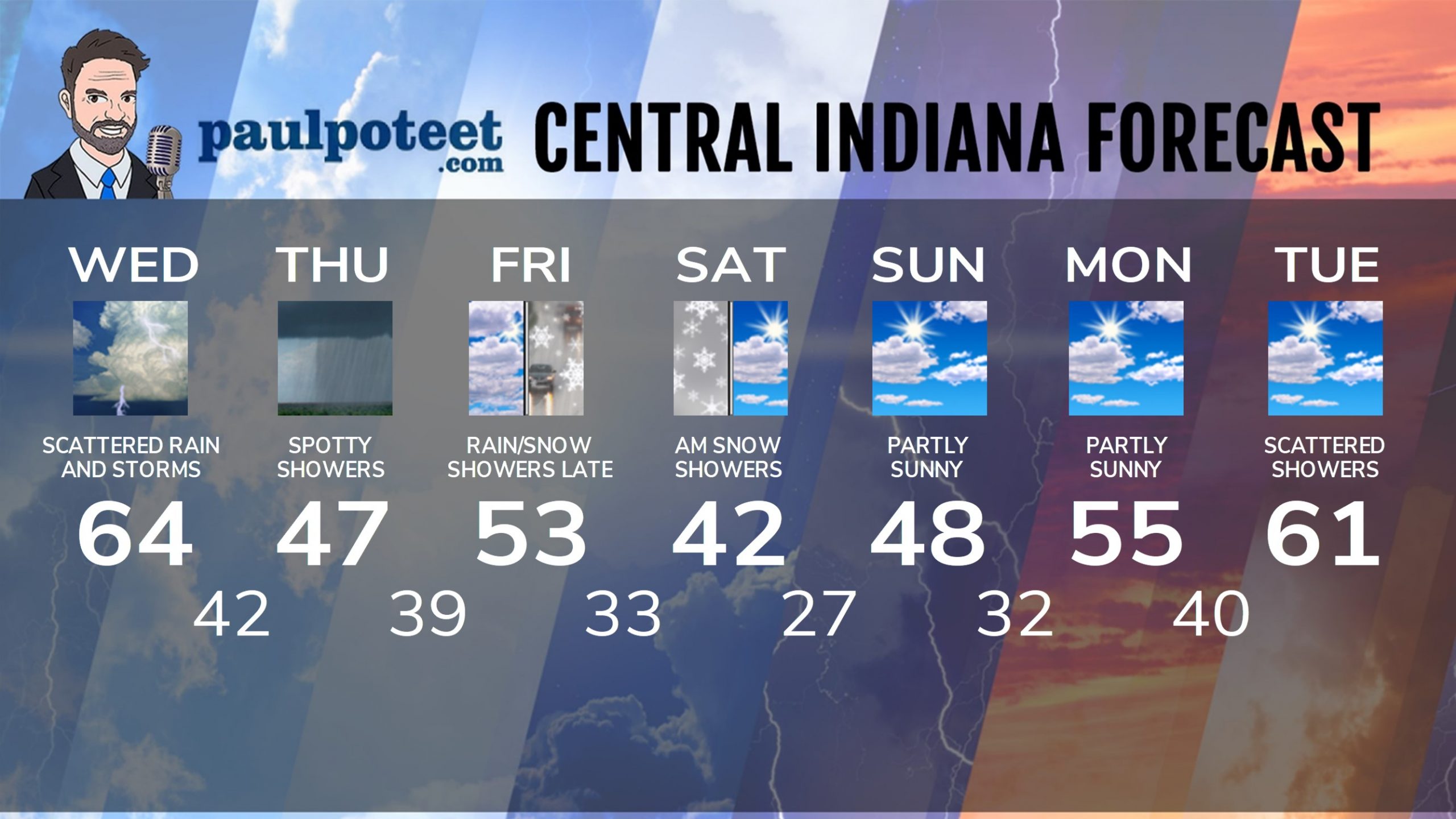
INDY SEVEN DAY FORECAST
Today: Scattered showers in the morning. Scattered showers and storms in the afternoon, and a few could be severe. Wind gusts to 30 mph even outside of storms. High 64.
Tonight: Scattered showers in the evening. Low 42.
Thursday: Cloudy, with a few spotty showers. High 47.
Thursday Night: Mostly cloudy. Low 39.
Friday: Mostly cloudy. Spotty afternoon showers. High 53.
Friday Night: Spotty rain and/or snow showers. Low 33.
Saturday: A few morning snow showers, then mostly to partly cloudy. High 42.
Saturday Night: Partly cloudy. Low 27.
Sunday: Partly sunny. High 48.
Sunday Night: Partly cloudy. Low 32.
Monday: Partly sunny. High 55.
Monday Night: Clouding up. Showers late. Low 40.
Tuesday: Mostly cloudy, with scattered showers. High 61.
Never miss me! Subscribe for free. My Huge Radar has real-time weather tracking, current temperatures, and severe weather watches and warnings. Get detailed Indiana conditions by clicking here. Click here to see my central Indiana 7-Day Forecast. Follow these links to get my forecasts for Lafayette, Muncie, Hendricks County, and Hamilton County. Need a second opinion? Click here for central Indiana National Weather Service forecasts. (Some charts via WeatherBELL.)


