TWO days of active weather this week and ONE of them is on TWOsday 2/22/22.
A Flood Watch continues for most of central Indiana. Up to two inches of rain may fall, especially south/southeast of Indy.

Rain ends early this evening, and cold air returns. Day number TWO of active weather comes Thursday. Mainly snow in central Indiana, with some sleet and freezing rain mixed in. Final sleet/snow totals could reach up to four inches around Lafayette, three inches around Muncie, and two inches in the Indy metro area.
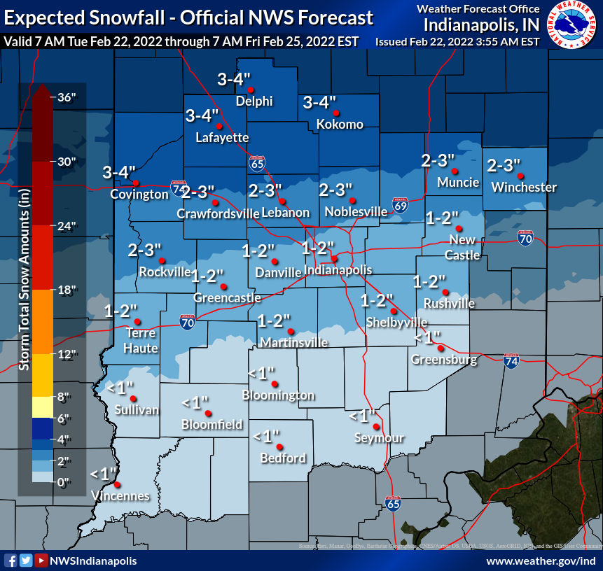
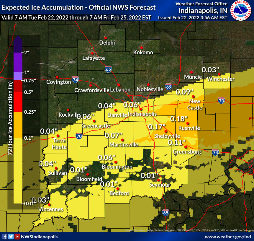
A glaze of ice can also form on surfaces Thursday in the southeast half of the state.
Never miss me! Subscribe for free. My Huge Radar has real-time weather tracking, current temperatures, and severe weather watches and warnings. Get detailed Indiana conditions by clicking here. Click here to see my central Indiana 7-Day Forecast. Follow these links to get my forecasts for Lafayette, Muncie, Hendricks County, and Hamilton County. Need a second opinion? Click here for central Indiana National Weather Service forecasts. (Some charts via WeatherBELL.)
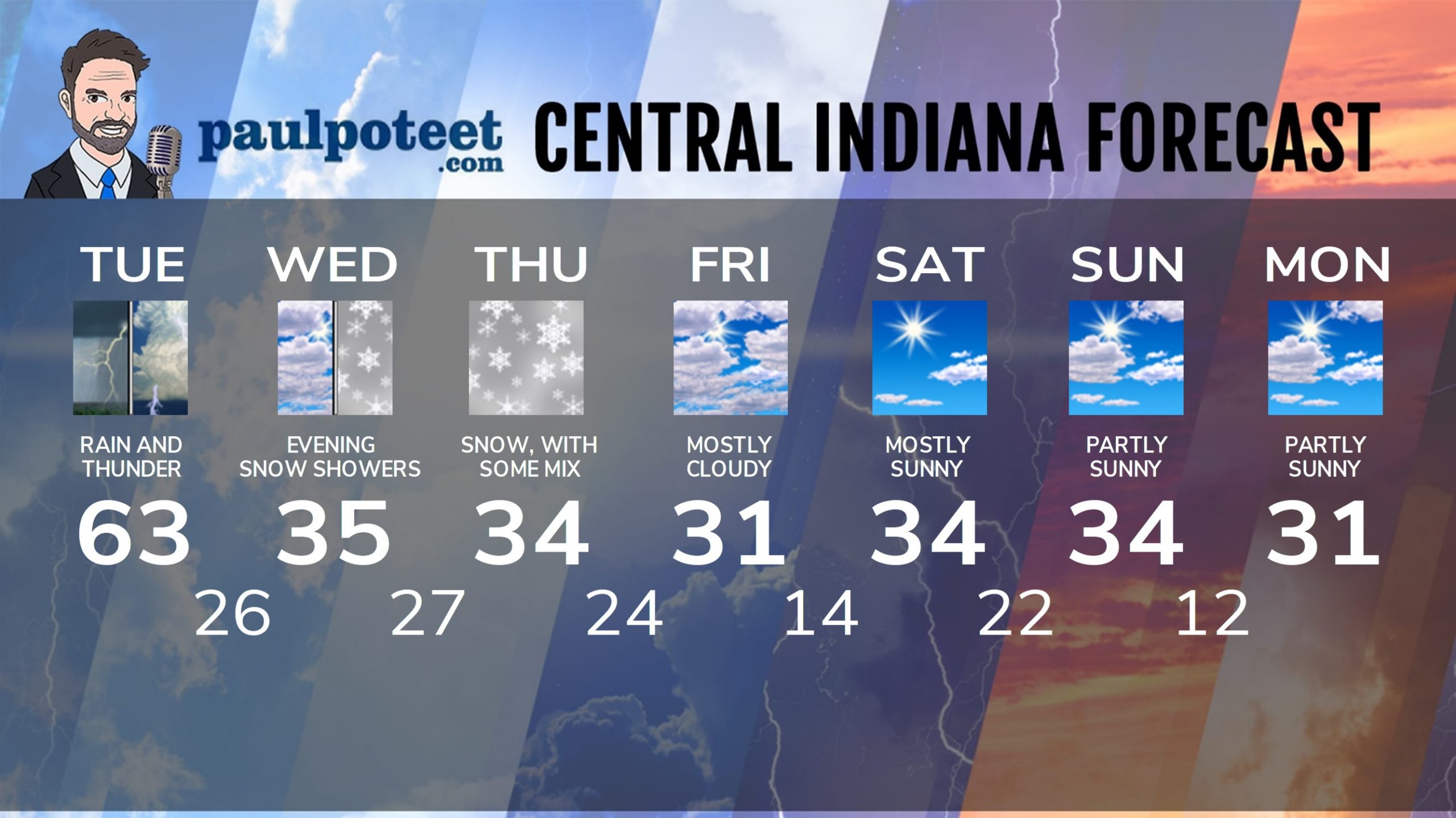
Today: Morning rain and some thunder. Scattered showers and storms in the afternoon. FLOOD WATCH continues. High 63.
Tonight: Showers end early, then mostly cloudy and colder. Low 26.
Wednesday: Mostly to partly cloudy. Late afternoon scattered snow showers. High 35.
Wednesday Night: Scattered snow showers. Low 27.
Thursday: Snow likely. Snow could mix with sleet and freezing rain. High 34.
Thursday Night: Snow likely. Snow could mix with sleet and freezing rain. Snow/sleet totals of 1-2 inches. Low 24.
Friday: Mostly cloudy. High 31.
Friday Night: Partly cloudy. Low 14.
Saturday: Mostly sunny. High 34.
Saturday Night: Mostly clear. Low 22.
Sunday: Partly sunny. High 34.
Sunday Night: Partly cloudy. Low 12.
Monday: Partly sunny. High 31.
Never miss me! Subscribe for free. My Huge Radar has real-time weather tracking, current temperatures, and severe weather watches and warnings. Get detailed Indiana conditions by clicking here. Click here to see my central Indiana 7-Day Forecast. Follow these links to get my forecasts for Lafayette, Muncie, Hendricks County, and Hamilton County. Need a second opinion? Click here for central Indiana National Weather Service forecasts. (Some charts via WeatherBELL.)


