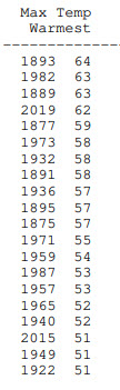
It’s likely the Christmas Day maximum temperature will be in the Top 5 of recorded-history highs. It’s possible it could be a new track record. This is a list of warmest Indy highs on December 25.
I remember the flipside well. I worked Christmas morning 1983, and we didn’t have a garage back then. Wasn’t sure my car would start. The morning low was -15 and the afternoon high was -4!
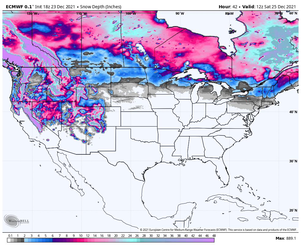
Here’s one computer-modeled look at expected snow depth on Christmas Day. Sorry Bing!
Never miss me! Subscribe for free. My Huge Radar has real-time weather tracking, current temperatures, and severe weather watches and warnings. Get detailed Indiana conditions by clicking here. Click here to see my central Indiana 7-Day Forecast. Follow these links to get my forecasts for Lafayette, Muncie, Hendricks County, and Hamilton County. Need a second opinion? Click here for central Indiana National Weather Service forecasts. (Some charts via WeatherBELL.)
INDY SEVEN DAY FORECAST
Friday: Clouds, breezy, and mild. Drizzle possible. High 57.
Christmas Eve: Mostly cloudy, breezy, and mild. Drizzle in the evening. Showers after midnight. Low 53.
Christmas Day: Mostly cloudy, breezy, with periods of showers, mainly in the morning. Partly sunny later. High 63.
Saturday Night: Partly cloudy. Low 36.
Sunday: Partly sunny. High 49.
Sunday Night: Periods of showers. Low 44.
Monday: Mostly cloudy, with scattered showers in the morning. High 60.
Monday Night: Mostly cloudy, with scattered showers late. Low 40.
Tuesday: Rainy. High 55.
Tuesday Night: Rainy. Low 43.
Wednesday: Mostly cloudy, with scattered showers. High 58.
Wednesday Night: Partly to mostly cloudy. Scattered showers. Low 33.
Thursday: Partly sunny. High 44.

Never miss me! Subscribe for free. My Huge Radar has real-time weather tracking, current temperatures, and severe weather watches and warnings. Get detailed Indiana conditions by clicking here. Click here to see my central Indiana 7-Day Forecast. Follow these links to get my forecasts for Lafayette, Muncie, Hendricks County, and Hamilton County. Need a second opinion? Click here for central Indiana National Weather Service forecasts. (Some charts via WeatherBELL.)


