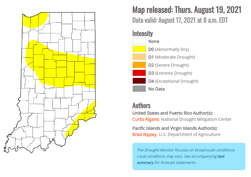
The latest Drought Monitor released this morning now shows much of central Indiana under “abnormally dry” conditions.
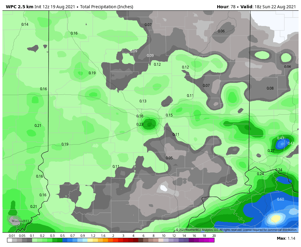
We could pick up a little rain again late this afternoon and evening, with a better chance Saturday afternoon. What do we get? Not a lot…a quarter-inch or less is expected through Saturday.
The humidity will drop just a bit Sunday afternoon through Monday morning, but that’s the only break for the next seven days.
Never miss me! Subscribe for free. My Huge Radar has real-time weather tracking, current temperatures, and severe weather watches and warnings. Get detailed Indiana conditions by clicking here. Click here to see my central Indiana 7-Day Forecast. Follow these links to get my forecasts for Lafayette, Muncie, Hendricks County, and Hamilton County. Need a second opinion? Click here for central Indiana National Weather Service forecasts. (Some charts via WeatherBELL.)
INDY SEVEN DAY FORECAST
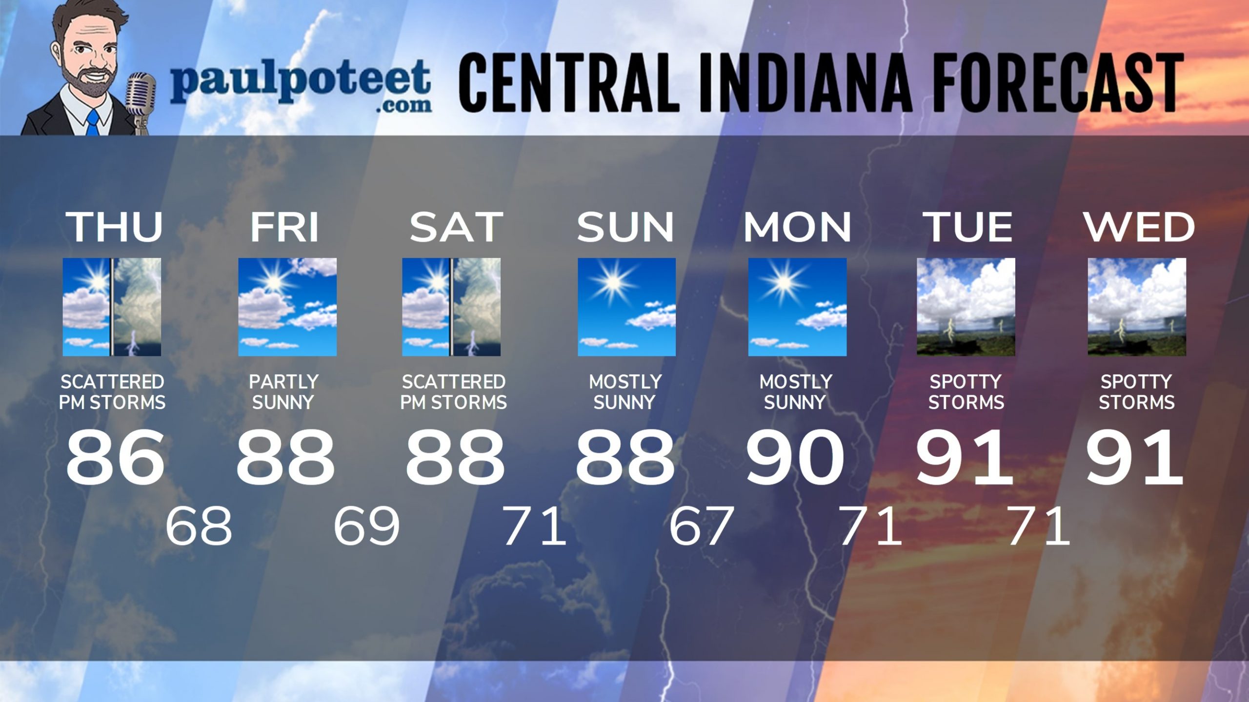
Today: Partly sunny. Patchy morning fog. Scattered showers and storms in the early morning south and southeast of Indy. Scattered afternoon showers and storms elsewhere. High 86.
Tonight: Scattered shower or storm possible in the evening, then partly cloudy. Low 68.
Friday: Patchy morning fog. Partly sunny. High 88.
Friday Night: Mostly clear. Low 69.
Saturday: Partly sunny. Scattered showers and storms, mainly in the afternoon. High 88.
Saturday Night: Spotty shower or storm in the evening, then partly cloudy. Low 71.
Sunday: Partly to mostly sunny. High 88.
Sunday Night: Partly cloudy. Low 67.
Monday: Mostly sunny. High 90.
Monday Night: Partly cloudy. Low 71.
Tuesday: Partly sunny. Spotty showers and storms. High 91.
Tuesday: Partly sunny. Low 71.
Wednesday: Partly sunny. Spotty showers and storms. High 91.
Never miss me! Subscribe for free. My Huge Radar has real-time weather tracking, current temperatures, and severe weather watches and warnings. Get detailed Indiana conditions by clicking here. Click here to see my central Indiana 7-Day Forecast. Follow these links to get my forecasts for Lafayette, Muncie, Hendricks County, and Hamilton County. Need a second opinion? Click here for central Indiana National Weather Service forecasts. (Some charts via WeatherBELL.)


