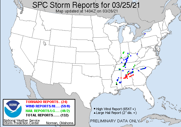
The wind gusted to 62 mph early Friday morning in Shelbyville, and reports of 45-55 mph gusts were common across the state. An inch of rain fell in Lafayette, with a little over one-half inch in Indy and Terre Haute, and a little under that in Bloomington. About one-third of an inch fell in Muncie.
Public Information Statement
National Weather Service Indianapolis IN
542 AM EDT Fri Mar 26 2021

...HIGHEST REPORTED PEAK WIND GUSTS for March 25-26, 2021...

Location in central Indiana   Speed    Time/Date       County

Shelbyville  Airport         62 MPH    0216 AM 03/26   Shelby
Indianapolis Intl Airport    55 MPH    0133 AM 03/26   Marion
Muncie Airport               53 MPH    0329 AM 03/26   Delaware
Westfield                    52 MPH    0112 AM 03/26   Hamilton
Bloomington Airport          51 MPH    1116 PM 03/25   Monroe
Indianapolis Reg Airport     51 MPH    0255 AM 03/26   Hancock
Whitestown 1.8 SE            51 MPH    0240 AM 03/26   Boone
Millhousen                   49 MPH    0300 AM 03/26   Decatur
New Palestine                49 MPH    0147 AM 03/26   Shelby
Avon 0.8 W (INDOT)           48 MPH    0200 AM 03/26   Hendricks
Indianapolis Exc Airport     48 MPH    0215 AM 03/26   Boone
Lewisville 3.3 N (INDOT)     47 MPH    0310 AM 03/26   Henry
Carmel                       46 MPH    0938 PM 03/25   Hamilton
W. Lafayette - Purdue U. AP  46 MPH    0206 AM 03/26   Tippecanoe
Indianapolis                 45 MPH    0122 AM 03/26   Marion
Indianapolis Eagle Creek AP  45 MPH    0225 AM 03/26   Marion
Terre Haute Airport          45 MPH    1204 AM 03/26   Vigo
Anderson                     44 MPH    0309 AM 03/26   Madison
Bloomington                  44 MPH    1212 AM 03/26   Monroe
Greensburg (INDOT)           44 MPH    0340 AM 03/26   Decatur
Greenwood Airport            44 MPH    0155 AM 03/26   Johnson
Mooresville                  42 MPH    0133 AM 03/26   Morgan
Plainfield                   42 MPH    0101 AM 03/26   Hendricks
Columbus 2.5 W (INDOT)       41 MPH    0200 AM 03/26   Bartholomew
Kokomo Airport               41 MPH    0321 AM 03/26   Howard
Mitchell                     41 MPH    1135 PM 03/25   Lawrence
Sullivan (Raws)              41 MPH    1210 AM 03/26   Sullivan
Vincennes 4.5 SW (INDOT)     41 MPH    1110 PM 03/25   Knox
Frankfort Airport            40 MPH    0235 AM 03/26   Clinton
Colfax 4.7 N (INDOT)         40 MPH    0320 AM 03/26   Clinton
Washington Airport           40 MPH    1135 PM 03/25   Daviess
Greenfield                   40 MPH    0302 AM 03/26   Hancock
Cortland 4.2 S (INDOT)       40 MPH    0110 AM 03/26   Jackson
Anderson 3.8 SSE             40 MPH    0256 AM 03/26   Madison
Acton                        40 MPH    0246 AM 03/26   Marion
Crawfordsville Airport       40 MPH    0215 AM 03/26   Montgomery
One storm system/cold front, with another one to come Saturday night. In between: a beautiful spring Saturday, with a one-day return to above average temperatures.
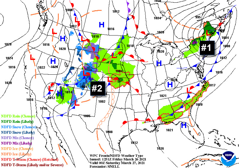
Storms Saturday night could produce large hail and damaging wind gusts, but the atmosphere won’t be packing the same punch it did late Thursday night and early Friday morning. Rain amounts should stay under a quarter of an inch.
Another nasty day in the Deep South Thursday, with two dozen tornado reports in Mississippi, Alabama, and Georgia.
Never miss me! Subscribe for free. My Huge Radar has real-time weather tracking, current temperatures, and severe weather watches and warnings. Get detailed Indiana conditions by clicking here. Click here to see my central Indiana 7-Day Forecast. Follow these links to get my forecasts for Lafayette, Muncie, Hendricks County, and Hamilton County. Need a second opinion? Click here for central Indiana National Weather Service forecasts. (Some charts via WeatherBELL.)
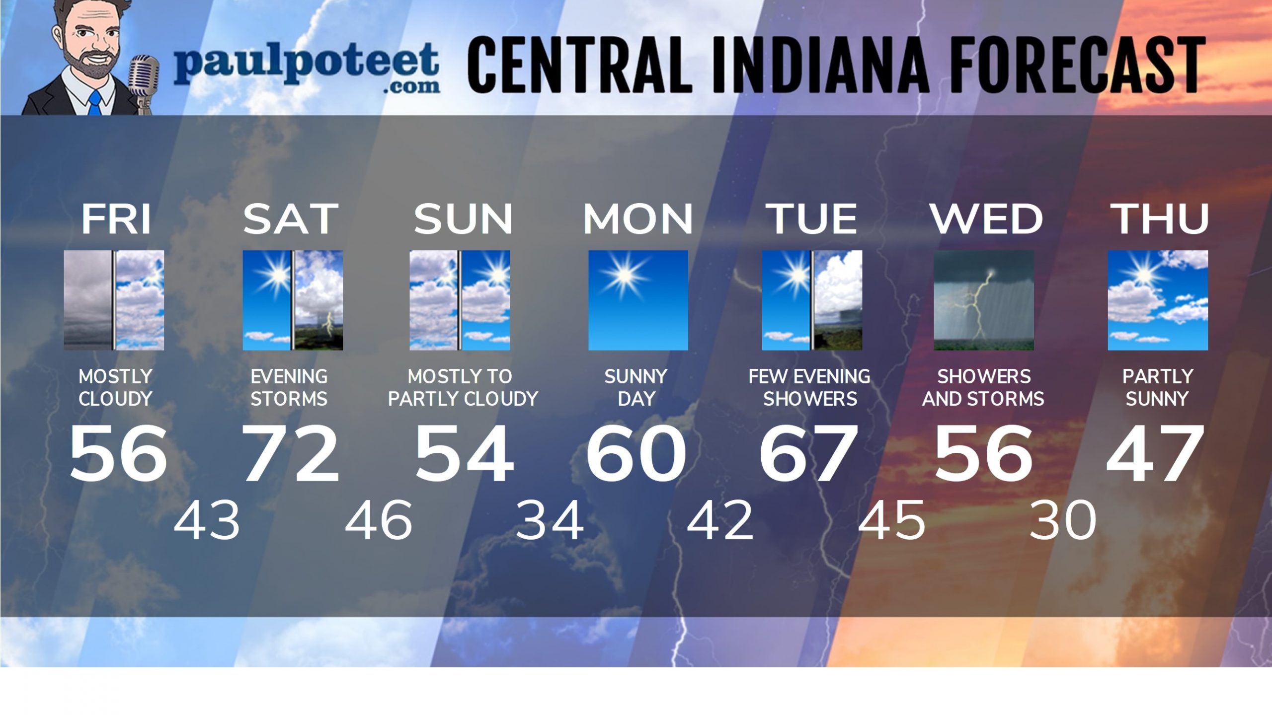
INDY SEVEN DAY FORECAST
Friday: Overcast in the morning, mostly cloudy in the afternoon. Still a little breezy in the morning. High 56.
Friday Night: Partly cloudy. Low 43.
Saturday: Partly to mostly sunny. High 72.
Saturday Night: Partly cloudy. Scattered showers and storms in the late evening and overnight. Low 46.
Sunday: Mostly cloudy morning. Partly sunny afternoon. High 54.
Sunday Night: Mostly clear. Low 34.
Monday: Mostly sunny. High 60.
Monday Night: Partly cloudy. Low 42.
Tuesday: Mostly to partly sunny. High 67.
Tuesday Night: Spotty showers. Low 45.
Wednesday: Periods of showers. Thunderstorms possible. High 56.
Wednesday Night: Scattered showers and storms early. Some clearing late. Low 30.
Thursday: Partly sunny and cooler. High 47.
Never miss me! Subscribe for free. My Huge Radar has real-time weather tracking, current temperatures, and severe weather watches and warnings. Get detailed Indiana conditions by clicking here. Click here to see my central Indiana 7-Day Forecast. Follow these links to get my forecasts for Lafayette, Muncie, Hendricks County, and Hamilton County. Need a second opinion? Click here for central Indiana National Weather Service forecasts. (Some charts via WeatherBELL.)


