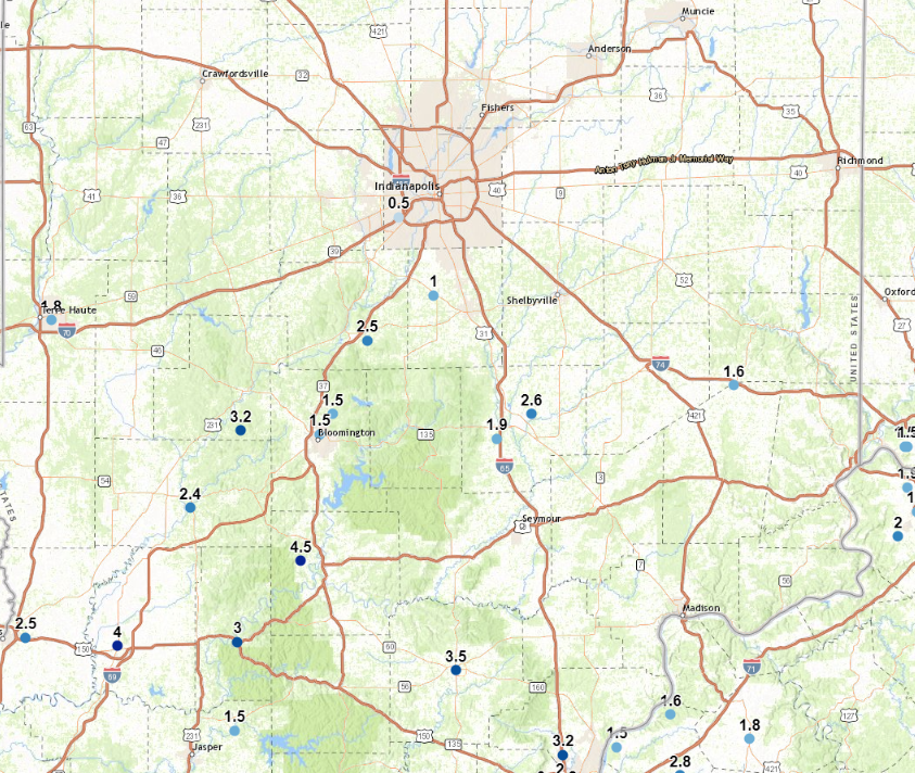
A half-inch of snow accumulated in Indy Wednesday, raising the seasonal total to 6.2 inches. That’s less than half of the normal average at this point: 15.4 inches. Here’s a look at the heavier snow reports in the southern third of the state.
This weekend’s winter storm will bring both rain and snow as low pressure rolls right over the state.
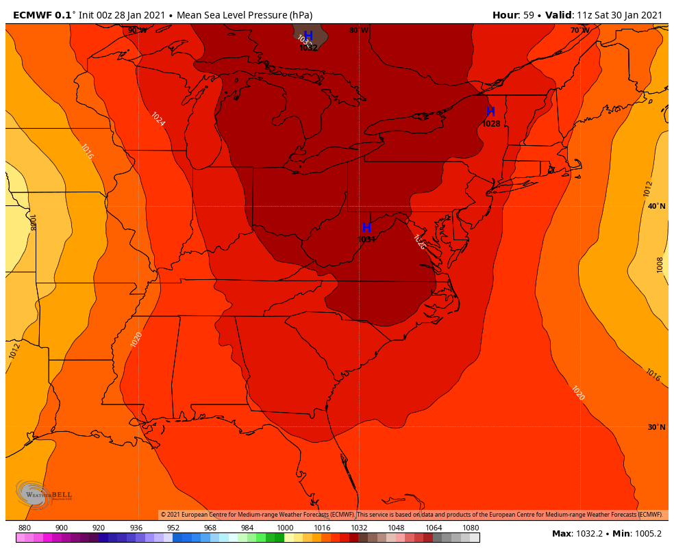
The most likely time for snow accumulation is late Saturday night and Sunday morning. It’s possible the snow could get heavier north/east of Indianapolis. Here’s an early prediction from the Weather Service.

Never miss me! Subscribe for free. My Huge Radar has real-time weather tracking, current temperatures, and severe weather watches and warnings. Get detailed Indiana conditions by clicking here. Click here to see my central Indiana 7-Day Forecast. Follow these links to get my forecasts for Lafayette, Muncie, Hendricks County, and Hamilton County. Need a second opinion? Click here for central Indiana National Weather Service forecasts. (Some charts via WeatherBELL.)
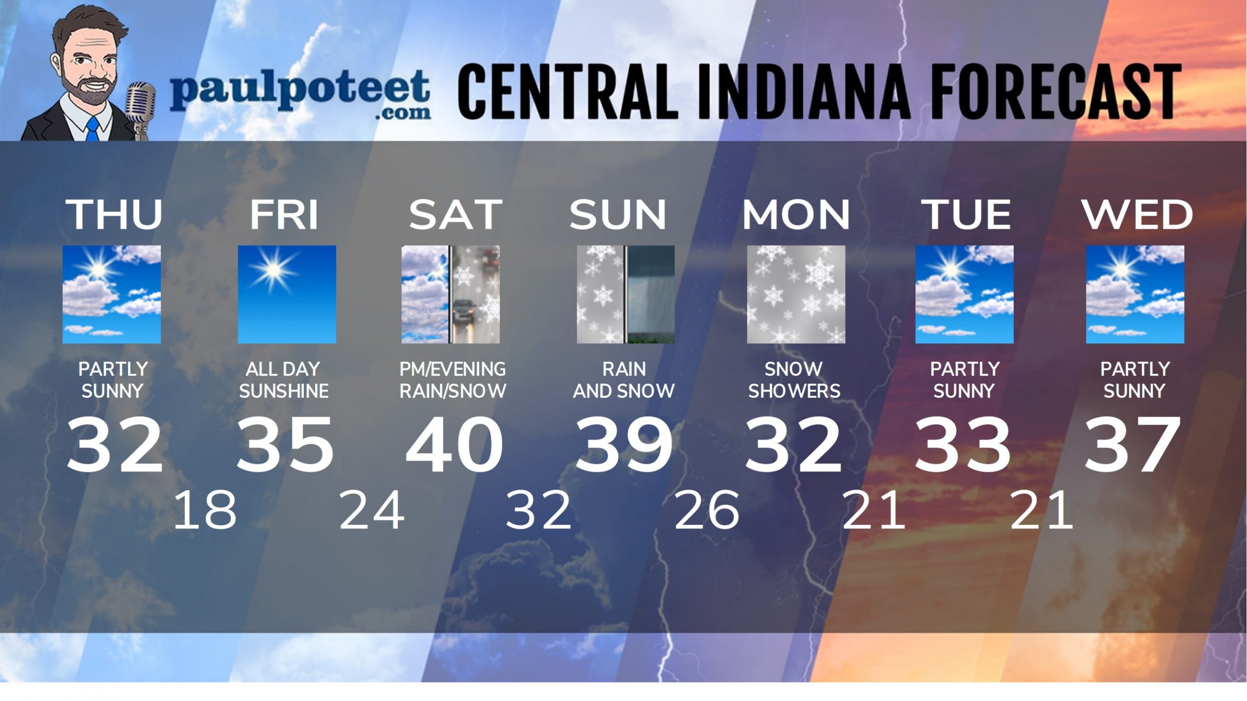
INDY SEVEN DAY FORECAST
Today: Partly sunny. High 32.
Tonight: Mostly clear. Low 18.
Friday: Sunny. High 35.
Friday Night: Partly cloudy. Low 24.
Saturday: Clouds increasing. Rain and snow in the afternoon. High 40.
Saturday Night: Snow and rain. Accumulating snow possible. Low 32.
Sunday: Rain and snow. Accumulating snow possible. High 39.
Sunday Night: Snow showers. Low 26.
Monday: Cloudy, with snow showers. High 32.
Monday Night: Mostly cloudy. Low 21.
Tuesday: Partly sunny. High 33.
Tuesday Night: Mostly cloudy. Low 21.
Wednesday: Partly sunny. High 37.
Never miss me! Subscribe for free. My Huge Radar has real-time weather tracking, current temperatures, and severe weather watches and warnings. Get detailed Indiana conditions by clicking here. Click here to see my central Indiana 7-Day Forecast. Follow these links to get my forecasts for Lafayette, Muncie, Hendricks County, and Hamilton County. Need a second opinion? Click here for central Indiana National Weather Service forecasts. (Some charts via WeatherBELL.)


