 How many more mild days? I count two, before the cold front arrives Friday. There will be more clouds around Wednesday afternoon, and even more by Thursday.
Additionally there are patches of Wednesday morning fog, so ya may be a little thick around places like Lafayette and Marion. We missed the record by three degrees yesterday, and will miss it by about four degrees today and tomorrow. But STILL…
The game-changer arrives by Friday morning. Here’s your cold front.
How many more mild days? I count two, before the cold front arrives Friday. There will be more clouds around Wednesday afternoon, and even more by Thursday.
Additionally there are patches of Wednesday morning fog, so ya may be a little thick around places like Lafayette and Marion. We missed the record by three degrees yesterday, and will miss it by about four degrees today and tomorrow. But STILL…
The game-changer arrives by Friday morning. Here’s your cold front.
 Ahead of it: still a marginal risk of damaging wind gusts within thunderstorms. Here’s the map through 7am Friday.
 And here’s the map for 7am Friday-7am Saturday. Our storm threat should fade by afternoon.
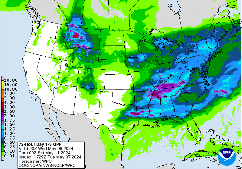
 Rain totals could exceed one-half inch from Indy southward:
 PAUL’S PREVIOUS PREDICTION
Yesterday’s high was 73. My forecast was 73.
INDY ALMANAC
The average high today is 58 and the average low is 39. Records are 78 and 16. The sun rises at 7:17 am and sets at 5:40 pm.
PAUL’S PREVIOUS PREDICTION
Yesterday’s high was 73. My forecast was 73.
INDY ALMANAC
The average high today is 58 and the average low is 39. Records are 78 and 16. The sun rises at 7:17 am and sets at 5:40 pm.
 INDY SEVEN DAY FORECAST
Today: Mostly sunny morning. Partly sunny afternoon. High 74.
Tonight: Partly cloudy. Low 57.
Thursday: Becoming mostly cloudy. High 72.
Thursday Night: Showers and storms likely. Low 60.
Friday: Morning showers or storms. Some sun later in the day. High 66.
Friday Night: Clearing and colder. Low 41.
Saturday: Partly sunny. High 55.
Saturday Night: Mostly clear. Low 35.
Sunday: Mostly sunny. High 52.
Sunday Night: Mostly clear. Low 34.
Monday: Partly sunny. High 58.
Monday Night: Partly cloudy. Low 42.
Tuesday: Partly sunny. Slight shower chance. High 58.
]]>
INDY SEVEN DAY FORECAST
Today: Mostly sunny morning. Partly sunny afternoon. High 74.
Tonight: Partly cloudy. Low 57.
Thursday: Becoming mostly cloudy. High 72.
Thursday Night: Showers and storms likely. Low 60.
Friday: Morning showers or storms. Some sun later in the day. High 66.
Friday Night: Clearing and colder. Low 41.
Saturday: Partly sunny. High 55.
Saturday Night: Mostly clear. Low 35.
Sunday: Mostly sunny. High 52.
Sunday Night: Mostly clear. Low 34.
Monday: Partly sunny. High 58.
Monday Night: Partly cloudy. Low 42.
Tuesday: Partly sunny. Slight shower chance. High 58.
]]>
Never miss me! Subscribe for free. My Huge Radar has real-time weather tracking, current temperatures, and severe weather watches and warnings. Get detailed Indiana conditions by clicking here. Click here to see my central Indiana 7-Day Forecast. Follow these links to get my forecasts for Lafayette, Muncie, Hendricks County, and Hamilton County. Need a second opinion? Click here for central Indiana National Weather Service forecasts. (Some charts via WeatherBELL.)


