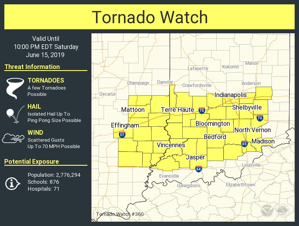
INDIANA'S WEATHERMAN:  | INDYSTAR@SUNRISE  | SMILEY/WZPL  | WQME 98.7  | 106/9 DOUBLE X-C  | NEWSTALK 95-3  | 479XX  | Q 102  | CONNECT MADCO
HOME | BIO | PAUL & TOM | PET PALS | INDIANA'S WEATHERMAN: FORECASTS  RADAR  INTERACTIVE  NEXT 3 HRS  ANYWHERE:    
INDIANA WARNINGS:  No watches or warnings at this time.  (More)
INDIANAPOLIS FORECAST:  Sunny and warmer. High 86. Breezy in the afternoon.  (More Indiana Forecasts)
INDIANAPOLIS TEMPERATURE:  65 via the Trust Homesense Heating & Cooling Thermostat.   (More Indiana Temperatures)

Posts tagged as:

Tornado Watch

Tornado Watch Map

May 1, 2012

t-watch

Here’s a map of a tornado watch for this afternoon and evening, which includes Indianapolis and points to the east and southeast. The watch goes until 10pm. Thunderstorms are expected to increase in coverage and intensity this afternoon along and south of a warm front that is lifting northward through Indiana. (You’ll notice the effects [...]

Read the full article →

Q102-land Evansville Forecast

February 29, 2012

q-102-blog-logo19

Today:  TORNADO WATCH until 9am.  Showers and storms this morning, with gusty winds.  Decreasing cloudiness this afternoon.  High 71. Tonight:  Mostly clear.  Low 41. Thursday:  Sunny.  High 62. Thursday Night:  Partly cloudy.  Low 49. Friday:  Chance of afternoon showers and storms.  High 74.

Read the full article →

Tuesday Indiana Weather Almanac

January 17, 2012

seven-day-indy-scaled

A mild and wild start in the state today. OVERNIGHT temperatures have been averaging about 20 degrees higher than our average high temp at this point in the winter. How spring-like is it? A tornado watch has been in place overnight in portions of central Illinois and Missouri. So far, just reports of large hail [...]

Read the full article →

January Tornado Watch

January 17, 2012

tornado-watch-scaled

You may hear some thunder this morning from Indy southward, and winds could gust to around 35 mph. Back to our west there is actually a Tornado Watch in place until 8am this morning. It covers southwest Illinois and a good chunk of Missouri. Track the rain on the Huge Radar here. Use interactive radar [...]

Read the full article →

Tornado Watch Until 8pm

November 14, 2011

watch

Here’s a map from the Storm Prediction Center showing a large portion of Indiana under a Tornado Watch until 8pm this evening.

Read the full article →

Sunday Tornado Watch For Northern Indiana

May 29, 2011

TORNADO-WATCH

Tornado Watch until 8pm for Indiana north of about Marion back to Lafayette. 80mph winds and possible tornadoes are a threat with these storms.

Read the full article →

What’s Next From The West?

May 25, 2011

845-update

Tornado Watch continues for much of the state until 2am. From the Storm Prediction Center: A SIGNIFICANT STRAIGHT-LINE WIND THREAT IS DEVELOPING FROM IL INTO INDIANA AND WRN KY. LATEST SURFACE MAP SHOWS TIGHT PRESSURE RISE/FALL COUPLET ASSOCIATED WITH THE CONGEALED LINE OF STORMS WITH EMBEDDED SUPERCELLS. WITH STRONG SHEAR PROFILES IN PLACE, THESE STORMS [...]

Read the full article →

Tornado Watch Until 7pm

May 25, 2011

tornado-watch

Most of Indiana is under a Tornado Watch until 7pm. There is a risk of severe weather statewide, with a moderate risk over much of central Indiana, and even a high risk from Evansville southward.

Read the full article →