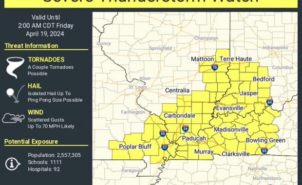
A SEVERE THUNDERSTORM WARNING REMAINS IN EFFECT UNTIL 1015 PM EDT FOR SOUTHERN VIGO…SULLIVAN…KNOX…SOUTHWESTERN CLAY…WESTERN GREENE AND NORTHWESTERN DAVIESS COUNTIES At 936 PM EDT, severe thunderstorms were located along a line extending from Martinsville to Robinson to Parkersburg, moving east at 40 mph. HAZARD…Up to 60 mph wind gusts and penny size hail. SOURCE…Radar indicated. […]
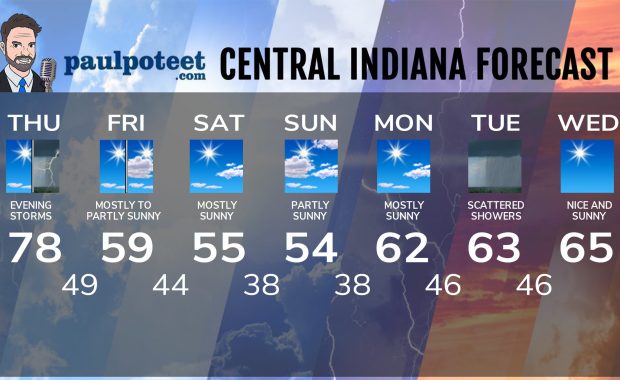
Never miss me! Subscribe for free. My Huge Radar has real-time weather tracking, current temperatures, and severe weather watches and warnings. Get detailed Indiana conditions by clicking here. Click here to see my central Indiana 7-Day Forecast. Follow these links to get my forecasts for Lafayette, Muncie, Hendricks County, and Hamilton County. Need a second opinion? Click here for central Indiana National Weather Service forecasts. (Some charts via WeatherBELL.)