

INTERACTIVE RADAR
INDIANA TRAFFIC CONDITIONS
INDY HIGHWAY TEMP
8:20am
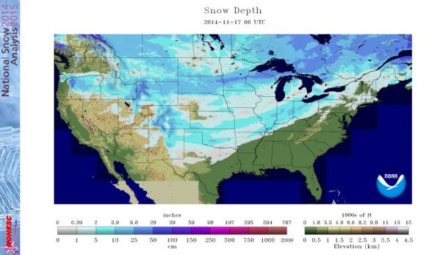
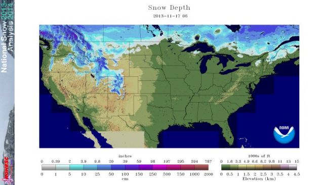
The first graphic shows snow cover this morning. The next: one year ago today.
8:20am
2.0″ Greenwood
2.4″ Lebanon
2.6″ Franklin
7:00am
The Indy Airport stayed just northwest of additional accumulation, so the storm total stays at 2.5 inches, which is the biggest November snow since 1997. Reports this morning range from 2-4 inches.
NOW: The Big Chill. Winds gust to 30 mph today, with single digit chills. Chills below zero tonight. We may see the first single digit lows in November since 1976.
CAUTION: Winds may whip a dusting of snow showers around from mid-late afternoon into evening.
6:45am
3.0″ Whiteland (Johnson Co.)
5:25am
More totals:
2.8″ Bedford
3.5″ Monrovia
3:35am
Afternoon rush hour could be worse than the morning, thanks to gusty wind and a dusting from snow showers.
PLENTY OF MID LEVEL ENERGY ROTATING AROUND THE BASE OF THE UPPER LOW
AND THROUGH THE REGION. THIS COMBINED WITH INTENSIFYING COLD
ADVECTION AND SHALLOW INSTABILITY WITH STEEPENING LAPSE RATES TO
850MB SUPPORT CONVECTIVE SNOW SHOWERS. WITH WIND GUSTS STEADILY
STRENGTHENING TO AROUND 30MPH THIS AFTERNOON...THESE SNOW
SHOWERS/SQUALLS HAVE THE POTENTIAL TO CREATE A GREATER IMPACT ON
TRAVEL THAN THE SNOW EXPERIENCED SUNDAY NIGHT AND EARLY THIS
MORNING. WHILE SNOWFALL WILL BE ONLY A DUSTING TO A FEW TENTHS OF AN
INCH AT BEST...THE SNOW WILL BE DRIER AND MUCH EASIER TO BLOW AROUND
WITH THE POTENTIAL FOR LOCALLY REDUCED VISIBILITY IN HEAVIER SNOW
SHOWERS. AS CRAZY AS THIS SOUNDS...HAVE A GROWING CONCERN THAT THE LATE
AFTERNOON/EVENING RUSH HOUR COULD BE MORE GREATLY IMPACTED THAN THIS
MORNING. WILL BE INTRODUCING AN SPS TO HIGHLIGHT THESE THREATS FOR
LATER TODAY.
2:55am
Weather Service notes that snowfall total for yesterday is the highest daily November number in 17 years for Indy.
2:45am
Snow should move completely out of Indy metro area by 9 or 10am.
2:30am
3.2″ Martinsville
2.9″ Indy NE Side
2.5″ Indy Official
3.0″ Edgewood (Madison Co.)
2.3″ Brazil
10:30pm
3.0″ Whitestown (Boone Co.)
3.0″ Monrovia (Morgan Co.)
3.5″ Frankfort
2.8″ Anderson
2.0″ Cicero
10:30pm
The ongoing forecast should hold, with a final total (by mid-morning Monday) of as little as 3, or as much as 5 inches around the Indy Metro counties. Here’s the short-term computer guidance on the early morning and morning drive hours, via weatherbell.com:
2am

3am

4am

5am

6am

7am

8am

9am

10:15pm
2.4″ Indianapolis Official
2.8″ Carmel
9:45pm
2.0″ Anderson
9:15pm
2.2″ Indianapolis Official Total
@PaulPoteet 2.5 inches here in Westfield. SR32 just east of 31.
— Daniel Hensley (@danielhensley) November 17, 2014
9:05pm
2.5″ Carmel
1.9″ Westfield
8:30pm
2.5″ Noblesville
2.0″ Selma (Delaware Co.)
1.3″ Whiteland (Johnson Co.)
8:10pm
1.5″ Muncie
8:05pm
2.0″ Carmel
8:00pm
2.2″ Lafayette
1.5″ Russiaville (Howard Co.)
1.2″ Brooklyn (Morgan Co.)
1.0″ Martinsville
7:50pm
3.3″ Frankfort
7:45pm
2.5″ Attica
2.3″ Monrovia
1.6″ Anderson
1.5″ Carmel
1.4″ Lafayette
7:30pm
New Totals:
3.0″ Waynetown (Montgomery County)
2.5″ Frankfort
1.1″ Indy/NE Side
1.0″ Cicero
0.9″ Beech Grove
7:10pm
Last year’s first inch-plus of snow in Indy didn’t arrive until December 5.
7:07pm
1.1" #snow on the snowboards at 7 pm at #Indy office. #INwx pic.twitter.com/uWxsVncQ64
— NWS Indianapolis (@NWSIndianapolis) November 17, 2014
6:40pm
Chad Evans, Chief Meteorologist at WLFI in West Lafayette measures 1.4″.
6:10pm
Here are some updated snow forecast totals via NWS in Indy:

Here’s the latest text from the Weather Service explaining the Weather Advisory.
5:45pm
Meanwhile: A Tornado Watch in Louisiana. A real one.

5:30pm
NWS reports .5″ snow so far in Lafayette.
5:30pm
Somebody on Facebook already asked about these definitions. (You can read more here.)

4:30pm
NWS Indianapolis has 0.2″ so far.
3:30pm
NWS has bumped forecast up to 3-5 inches.
2:00pm
Heaviest snow should fall between 6pm tonight and 6am Monday. Here’s a look at some pretty consistent computer model depictions via weatherbell.com of snowfall by early afternoon Monday. Keep in mind that the totals represent a simple 10:1 formula (inch of rain=ten inches snow) and with the temps expected, we could see a higher ratio. The average shown here is right at 3 inches, using the 10:1 scheme.


2:00pm
Lots of Colts Blue on this model depiction, post-game tonight.

And it’s just wrapping up around sunrise Monday.

10:30am
The snomg.net URL is baaack! And it may have led you here, an address you can bookmark for the duration.
Late morning note from the National Weather Service
.NEAR TERM /REST OF TODAY/...

ISSUED AT 940 AM EST SUN NOV 16 2014

1430Z UPDATE...GOOD NEWS/BAD NEWS WITH THIS LATE MORNING UPDATE.
THE GOOD NEWS IS THAT THE FORECAST APPEARS TO BE RIGHT ON
TRACK. AND THE BAD NEWS IS THAT YES...THE FORECAST APPEARS TO BE
RIGHT ON TRACK FOR ADVISORY CONDITIONS DEVELOPING ACROSS MOST OF
CENTRAL INDIANA LATER TODAY AND CONTINUING OVERNIGHT.
Around three inches of snow will fall in much of Central Indiana between mid to late afternoon Sunday and around sunrise Monday. A Winter Weather Advisory is out for 5pm Sunday through 9am Monday. After the snow: wind chills near zero by Monday night.
Computer guidance has the snow spreading eastward into the Indy Metro area by about 4pm.

You’ll need to clear off your vehicle post-Colts tonight before heading home. Expect a slower Monday morning commute also.

Never miss me! Subscribe for free. My Huge Radar has real-time weather tracking, current temperatures, and severe weather watches and warnings. Get detailed Indiana conditions by clicking here. Click here to see my central Indiana 7-Day Forecast. Follow these links to get my forecasts for Lafayette, Muncie, Hendricks County, and Hamilton County. Need a second opinion? Click here for central Indiana National Weather Service forecasts. (Some charts via WeatherBELL.)


