Did we just have the last frosty morning until Fall? Mister Weatherman is thinking YES! Morning lows were as cold as 33 in Anderson, and 35 in Lafayette and the Haute. The low was 36 in Muncie, 37 in Kokomo, and 38 in Indy.
The big change to the weekend is the introduction of shower/storm chances Sunday. Biggest chances are early in the morning, and later in the afternoon.
Never miss me! Subscribe for free. My Huge Radar has real-time weather tracking, current temperatures, and severe weather watches and warnings. Get detailed Indiana conditions by clicking here. Click here to see my central Indiana 7-Day Forecast. Follow these links to get my forecasts for Lafayette, Muncie, Hendricks County, and Hamilton County. Need a second opinion? Click here for central Indiana National Weather Service forecasts. (Some charts via WeatherBELL.)
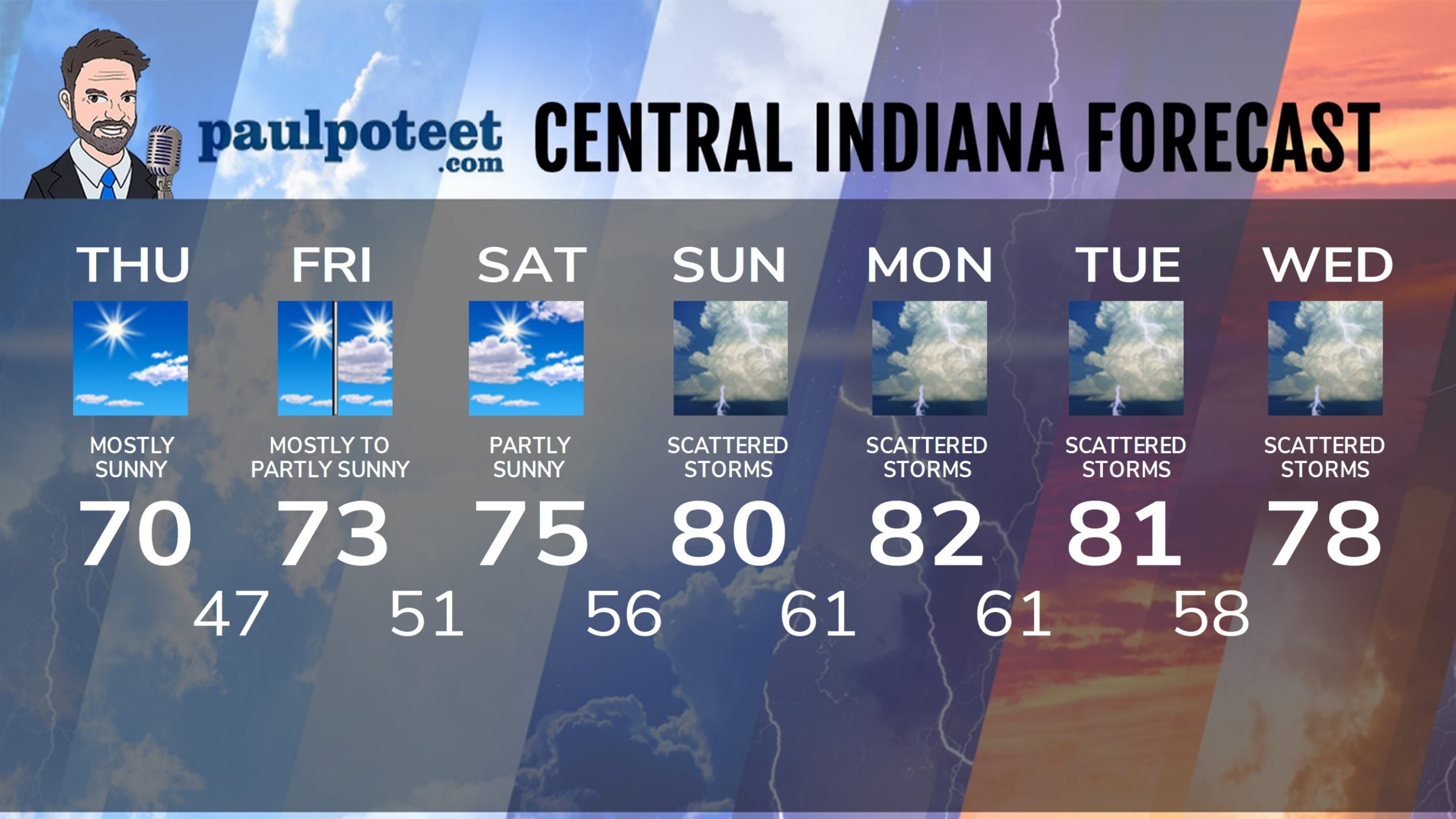
INDY SEVEN DAY FORECAST
Today: Mostly sunny. High 70.
Tonight: Mostly clear. Low 47.
Friday: Mostly sunny morning. Partly sunny afternoon. High 73.
Friday Night: Partly to mostly cloudy. Low 51.
Saturday: Partly sunny. High 75.
Saturday Night: Partly cloudy. Scattered showers and storms possible after midnight. Low 56.
Sunday: Partly to mostly cloudy. Scattered showers and storms, in the early morning and again in the afternoon. High 80.
Sunday Night: Scattered showers and storms. Low 61.
Monday: Partly to mostly cloudy, with scattered showers and storms. High 82.
Monday Night: Scattered showers and storms. Low 61.
Tuesday: Partly to mostly cloudy, with scattered showers and storms. High 81.
Tuesday Night: Scattered showers and storms. Low 58.
Wednesday: Partly to mostly cloudy, with scattered showers and storms. High 78.
Never miss me! Subscribe for free. My Huge Radar has real-time weather tracking, current temperatures, and severe weather watches and warnings. Get detailed Indiana conditions by clicking here. Click here to see my central Indiana 7-Day Forecast. Follow these links to get my forecasts for Lafayette, Muncie, Hendricks County, and Hamilton County. Need a second opinion? Click here for central Indiana National Weather Service forecasts. (Some charts via WeatherBELL.)


