There have been snow showers this morning from around Terre Haute and Greencastle east-southeastward toward Columbus and Greensburg. Those should become more widespread by afternoon. There could be “snow squalls,” sort of like thunderstorms only with snow. Visibility could be quickly reduced!
Never miss me! Subscribe for free. My Huge Radar has real-time weather tracking, current temperatures, and severe weather watches and warnings. Get detailed Indiana conditions by clicking here. Click here to see my central Indiana 7-Day Forecast. Follow these links to get my forecasts for Lafayette, Muncie, Hendricks County, and Hamilton County. Need a second opinion? Click here for central Indiana National Weather Service forecasts. (Some charts via WeatherBELL.)
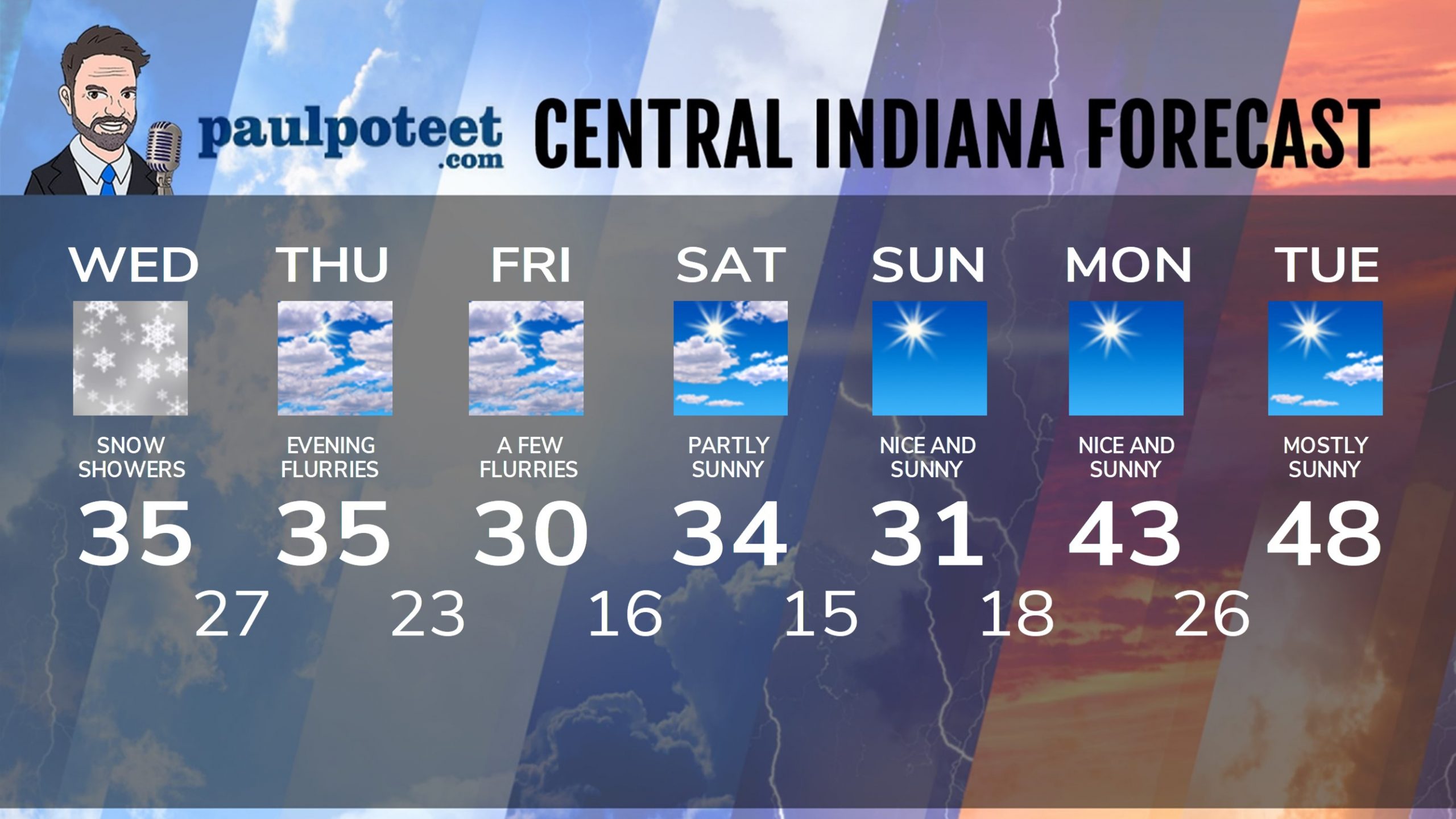
INDY SEVEN DAY FORECAST
Today: Mostly cloudy, with some snow showers or squalls. Little accumulation, but visibilities could suddenly be limited. Wind gusting to 25 mph. High 35.
Tonight: Evening snow showers. Wind gusting to 25 mph. Low 27.
Thursday: Mostly cloudy, with a few flurries. High 35.
Thursday Night: Mostly cloudy, with flurries and a few snow showers. Little or no accumulation. Low 23.
Friday: Mostly cloudy, with a few flurries. Wind gusting to 25 mph. High 30.
Friday Night: Partly cloudy. Low 16.
Saturday: Partly sunny. High 34.
Saturday Night: Mostly clear. Low 15.
Sunday: Sunny. High 31.
Sunday Night: Clear. Low 18.
Monday: Sunny. High 43.
Monday Night: Clear. Low 26.
Tuesday: Mostly sunny. High 48.
Never miss me! Subscribe for free. My Huge Radar has real-time weather tracking, current temperatures, and severe weather watches and warnings. Get detailed Indiana conditions by clicking here. Click here to see my central Indiana 7-Day Forecast. Follow these links to get my forecasts for Lafayette, Muncie, Hendricks County, and Hamilton County. Need a second opinion? Click here for central Indiana National Weather Service forecasts. (Some charts via WeatherBELL.)


