Friday begins with the coolest start since the first half of May. A brief bump is coming this weekend, with highs returning to the mid 70s, which is normal for this time of year. That’s the time in between a warm front (red line) and cold front (blue line) on this map.
There may be a few spotty showers coming and going with the two fronts, but most of the timing favors the overnight and early morning hours of both Saturday and Sunday. Surface high pressure and dry weather are the story next work week.
Never miss me! Subscribe for free. My Huge Radar has real-time weather tracking, current temperatures, and severe weather watches and warnings. Get detailed Indiana conditions by clicking here. Click here to see my central Indiana 7-Day Forecast. Follow these links to get my forecasts for Lafayette, Muncie, Hendricks County, and Hamilton County. Need a second opinion? Click here for central Indiana National Weather Service forecasts. (Some charts via WeatherBELL.)
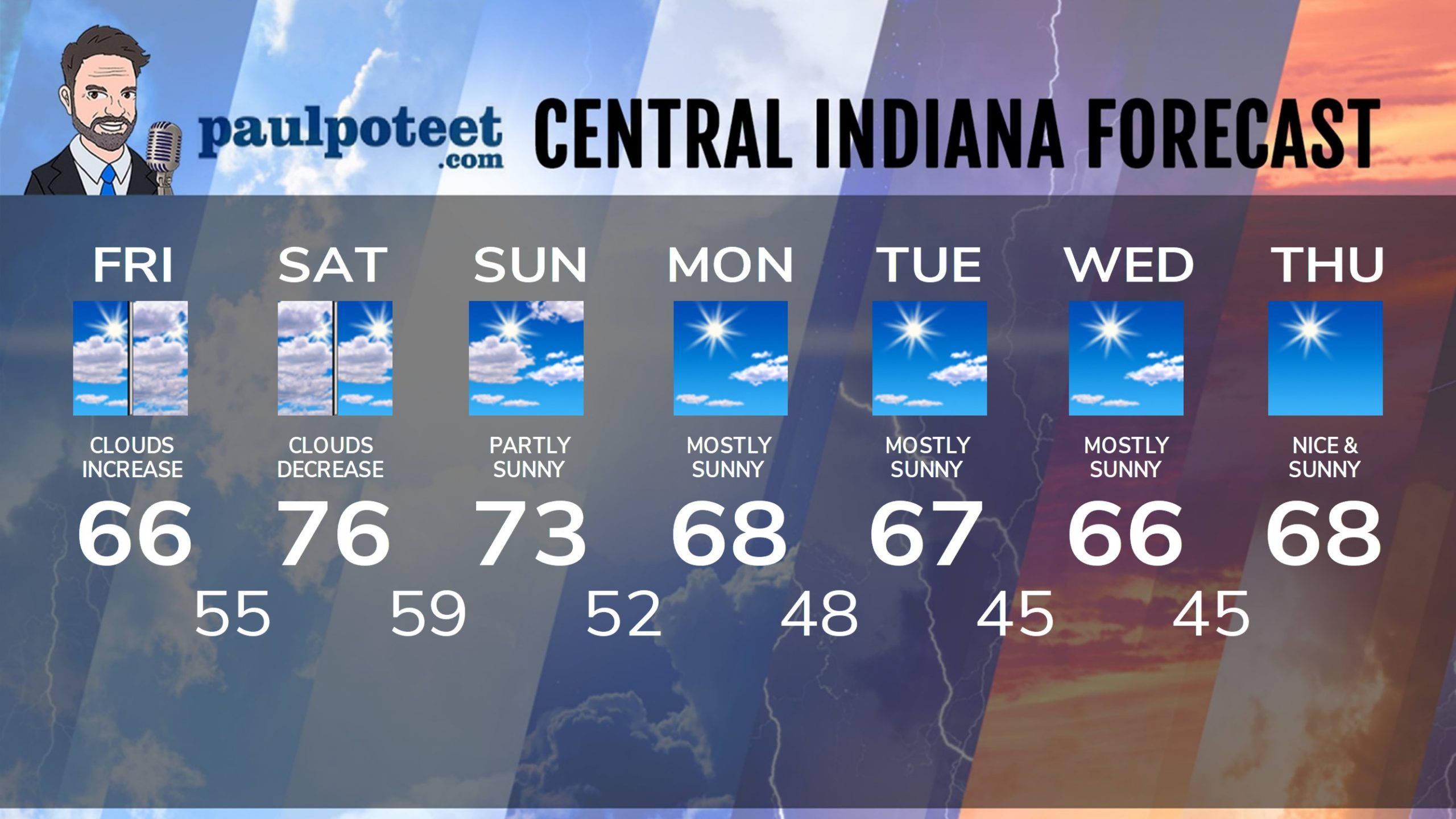
INDY SEVEN DAY FORECAST
Friday: Partly sunny to start. Becoming mostly cloudy in the afternoon. High 66.
Friday Night: Cloudy, with a spotty shower possible overnight. Low 55.
Saturday: Clouds early, decreasing through the day. High 76.
Saturday Night: Partly cloudy evening. Spotty shower possible overnight. Low 59.
Sunday: Becoming partly sunny. High 73.
Sunday Night: Partly cloudy. Low 52.
Monday: Mostly sunny. High 68.
Monday Night: Mostly clear. Low 48.
Tuesday: Mostly sunny. High 67.
Tuesday Night: Mostly clear. Low 45.
Wednesday: Mostly sunny. High 66.
Wednesday Night: Mostly clear. Low 45.
Thursday: Sunny. High 68.
Never miss me! Subscribe for free. My Huge Radar has real-time weather tracking, current temperatures, and severe weather watches and warnings. Get detailed Indiana conditions by clicking here. Click here to see my central Indiana 7-Day Forecast. Follow these links to get my forecasts for Lafayette, Muncie, Hendricks County, and Hamilton County. Need a second opinion? Click here for central Indiana National Weather Service forecasts. (Some charts via WeatherBELL.)


Indiana’s Weather For The Weekend:
Friday begins with the coolest start since the first half of May. A brief bump is coming this weekend, with highs returning to the mid…
https://t.co/VlUCgXeV3C https://t.co/8FvX6LmBuH
Perfect weather, as far as I’m concerned.
https://t.co/8NdM6wRBWP
RT @PaulPoteet: Indiana’s Weather For The Weekend:
Friday begins with the coolest start since the first half of May. A brief bump is comin…
Yeah even this Summer lover can live with 60s/70s.