Our minor meltdown continues today, but it will take awhile for the parking lot piles. It’s too thick! The snow closer to the top acts as an insulator for the snow buried deeper down. The compacted snow requires more energy—not just one sunny day—to dissipate. Rain helps a lot, and that’s in the forecast for Friday.
Never miss me! Subscribe for free. My Huge Radar has real-time weather tracking, current temperatures, and severe weather watches and warnings. Get detailed Indiana conditions by clicking here. Click here to see my central Indiana 7-Day Forecast. Follow these links to get my forecasts for Lafayette, Muncie, Hendricks County, and Hamilton County. Need a second opinion? Click here for central Indiana National Weather Service forecasts. (Some charts via WeatherBELL.)
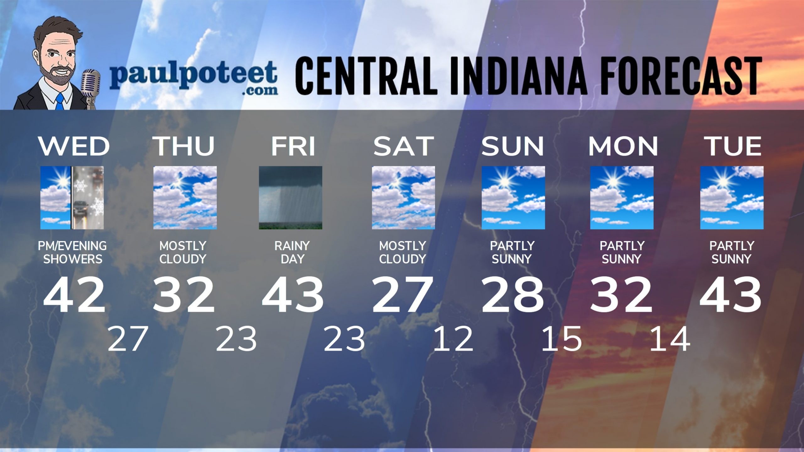
INDY SEVEN DAY FORECAST
Today: Partly to mostly cloudy. Spotty late afternoon shower possible. High 42.
Tonight: Partly to mostly cloudy, with a few rain or snow showers this evening. Low 27.
Thursday: Mostly cloudy, with a few snow showers in the morning. High 32.
Thursday Night: Partly cloudy. Temps rise after midnight. Low 23.
Friday: Rainy day. High 43.
Friday Night: Rain showers, possibly mixed with snow showers as it ends. Low 23.
Saturday: Mostly cloudy. High 27.
Saturday Night: Partly cloudy. Low 12.
Sunday: Partly sunny. High 28.
Sunday Night: Partly cloudy. Low 15.
Monday: Partly sunny. High 32.
Monday Night: Partly cloudy. Low 14.
Tuesday: Partly sunny. High 43.
Never miss me! Subscribe for free. My Huge Radar has real-time weather tracking, current temperatures, and severe weather watches and warnings. Get detailed Indiana conditions by clicking here. Click here to see my central Indiana 7-Day Forecast. Follow these links to get my forecasts for Lafayette, Muncie, Hendricks County, and Hamilton County. Need a second opinion? Click here for central Indiana National Weather Service forecasts. (Some charts via WeatherBELL.)


