The National Weather Service in Indianapolis survey damage from storms Thursday evening and confirmed two EF-1 tornadoes in Shelby County. Click here for details, pictures, etc.
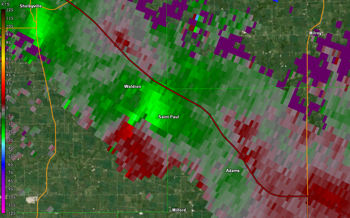
Public Information Statement
National Weather Service Indianapolis IN
643 PM EDT Fri Jul 30 2021

...NWS Damage Survey for 07/29/2021 Tornado Event ...

.Tornado #1...

Rating:                 EF-1
Estimated Peak Wind:    90 mph
Path Length /statute/:  2.50 miles
Path Width /maximum/:   50 yards
Fatalities:             0
Injuries:               0

Start Date:             07/29/2021
Start Time:             07:58 PM EDT
Start Location:         3 SE of Shelbyville
Start Lat/Lon:          39.484/-85.7357

End Date:               07/29/2021
End Time:               08:04 PM EDT
End Location:           2 W of Waldron
End Lat/Lon:            39.455/-85.707

The first tornado of the day initially began as a funnel cloud
over Shelbyville with roof damage to a building across the
southeast part of town.  This funnel cloud continued until
it touched down northwest of a small subdivision off of CR 250 E.
There it damaged numerous trees and damaged support beams on a porch.
A masonry wall was also knocked down.  The tornado continued to the
southeast where it caused tree damage to a home on CR 350S. The
most extensive tree damage would occur along CR 375E near 500S where
two homes had widespread tree damage along with an antenna pole
that was snapped.  The tornado then lifted in a field to the southeast.
The damage path was not always clear at all times, but it appears that
the tornado was either on the ground or just off the ground through
the duration.

.Tornado #2...

Rating:                 EF-1
Estimated Peak Wind:    90 mph
Path Length /statute/:  0.71 miles
Path Width /maximum/:   50 yards
Fatalities:             0
Injuries:               0

Start Date:             07/29/2021
Start Time:             08:14 PM EDT
Start Location:         2 S Waldron
Start Lat/Lon:          39.4265/-85.6784

End Date:               07/29/2021
End Time:               08:15 PM EDT
End Location:           2 S Waldron
End Lat/Lon:            39.4168/-85.6744

This short lived tornado initially touched down near a river
cabin and caused a narrow but intense swath of tree damage
along CR 500E.  The tornado then crossed the Flatrock River
where it impacted the Van Pelt cemetery.  Several grave stones
were knocked over by the tornado with additional tree damage on
the property.  The tornado may have briefly lifted before touching
down again in a field to the south.

&&

EF Scale: The Enhanced Fujita Scale classifies tornadoes into the
following categories:

EF0...Weak......65 to 85 mph
EF1...Weak......86 to 110 mph
EF2...Strong....111 to 135 mph
EF3...Strong....136 to 165 mph
EF4...Violent...166 to 200 mph
EF5...Violent...>200 mph

NOTE:
The information in this statement is preliminary and subject to
change pending final review of the events and publication in NWS
Storm Data.
Never miss me! Subscribe for free. My Huge Radar has real-time weather tracking, current temperatures, and severe weather watches and warnings. Get detailed Indiana conditions by clicking here. Click here to see my central Indiana 7-Day Forecast. Follow these links to get my forecasts for Lafayette, Muncie, Hendricks County, and Hamilton County. Need a second opinion? Click here for central Indiana National Weather Service forecasts. (Some charts via WeatherBELL.)


