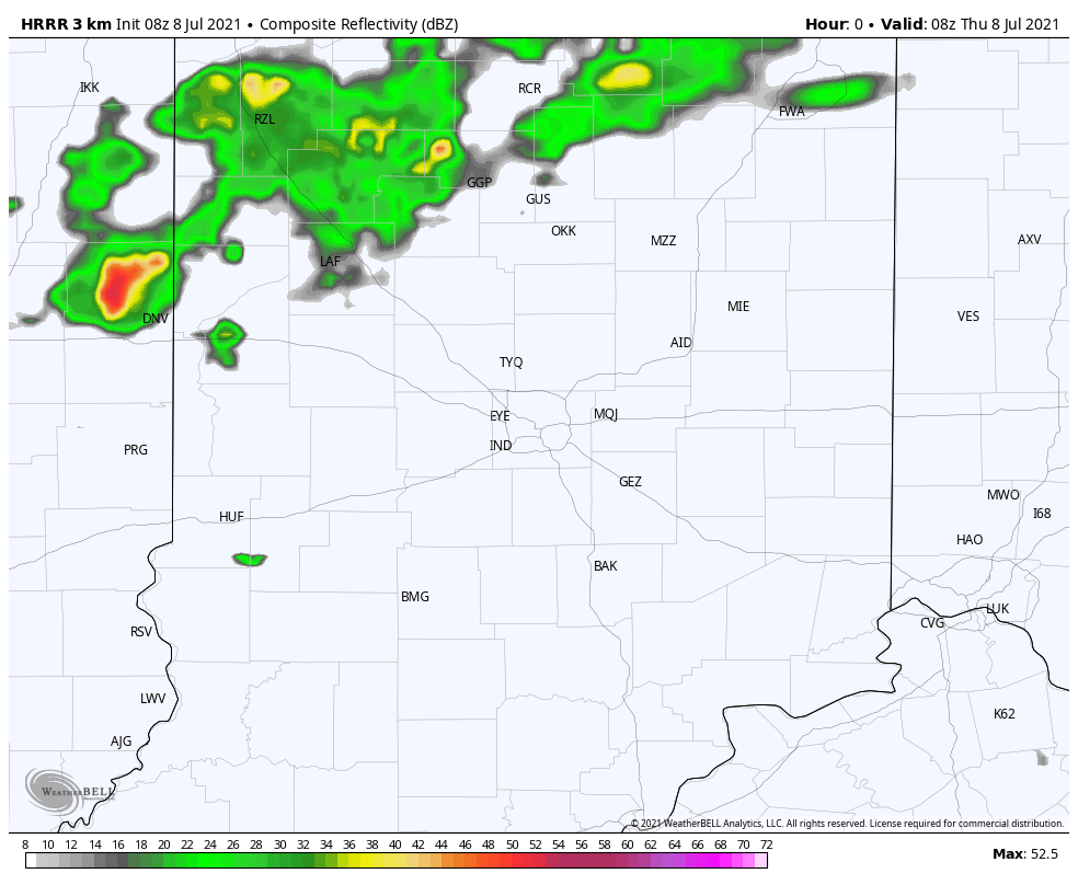
One morning round of rain and storms north of around Lebanon over to Anderson and Muncie. Storms this afternoon have a marginal (level one out of five) risk of producing severe weather.
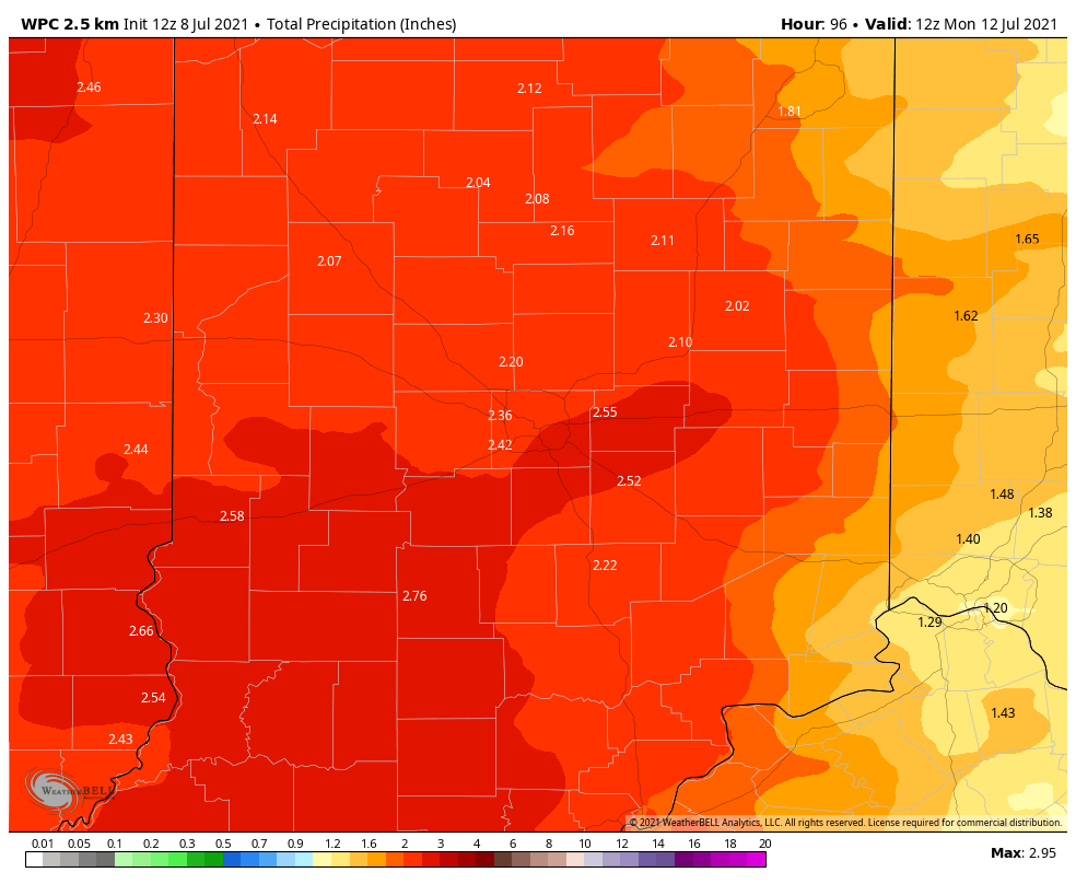
Humidity goes bye-bye Friday, but returns this weekend. I still think the biggest rain chances are Midnight-Noon Saturday, and all day Sunday, when rain could be heavy. Total rain by Monday morning could hit two inches.
Never miss me! Subscribe for free. My Huge Radar has real-time weather tracking, current temperatures, and severe weather watches and warnings. Get detailed Indiana conditions by clicking here. Click here to see my central Indiana 7-Day Forecast. Follow these links to get my forecasts for Lafayette, Muncie, Hendricks County, and Hamilton County. Need a second opinion? Click here for central Indiana National Weather Service forecasts. (Some charts via WeatherBELL.)
INDY SEVEN DAY FORECAST
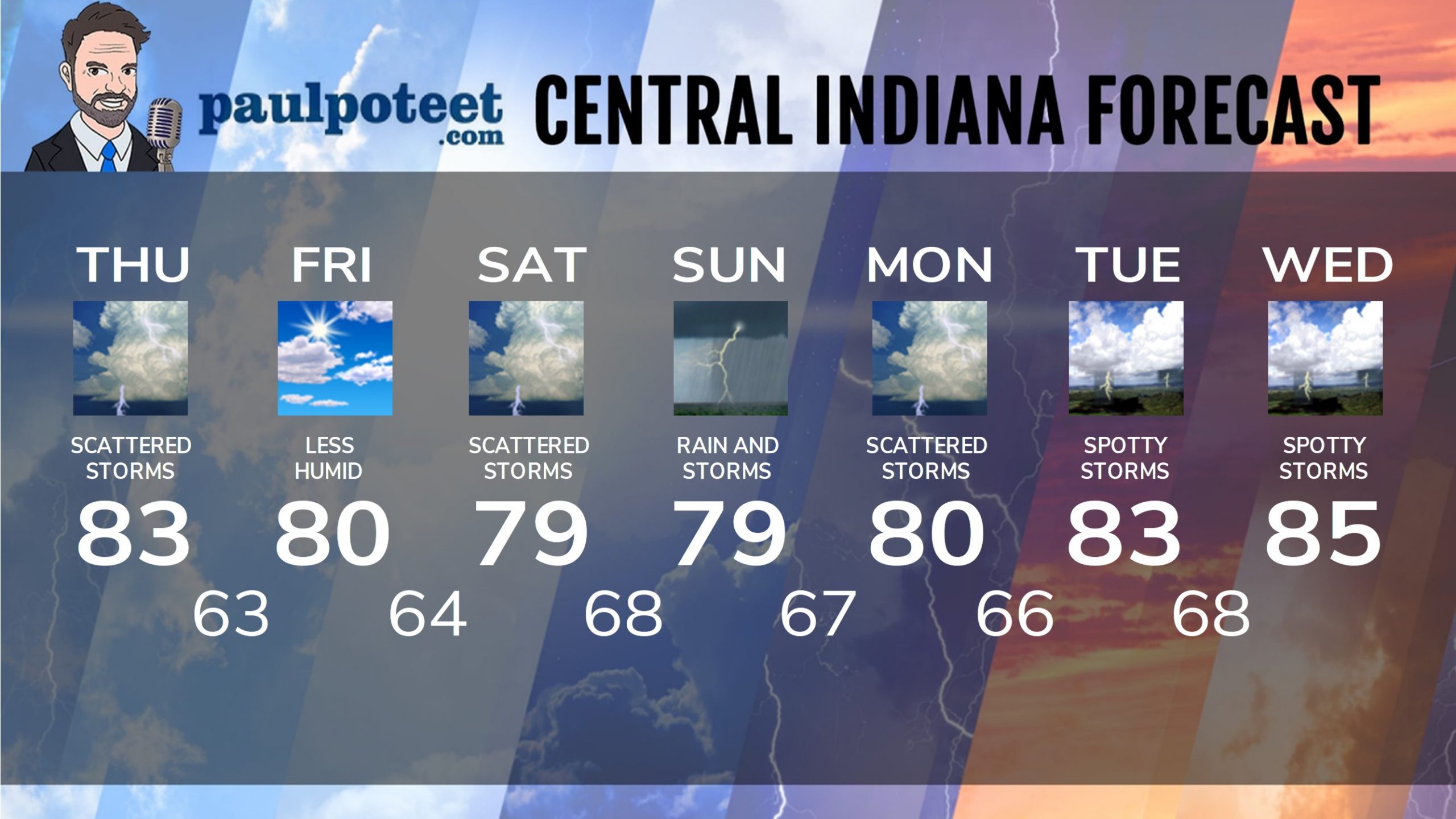
Today: Mostly cloudy, with scattered showers and storms, especially in the afternoon. High 83.
Tonight: Scattered showers and storms end around sunset, then partly cloudy and a little less humid after midnight. Low 63.
Friday: Partly sunny. Not as humid. High 80.
Friday Night: Clouding up, with showers and storms after midnight. Low 64.
Saturday: Periods of showers and storms in the morning. Spotty showers or storms possible in the afternoon. Humid again. High 79.
Saturday Night: Spotty showers or storms in the evening. Periods of showers and storms likely late. Low 68.
Sunday: Periods of showers and storms. High 79.
Sunday Night: Periods of showers and storms. Low 67.
Monday: Mostly cloudy, with scattered showers and storms. High 80.
Monday Night: Scattered showers and storms. Low 66.
Tuesday: Partly sunny. Spotty showers and storms. High 83.
Tuesday Night: Scattered showers and storms. Low 68.
Wednesday: Partly sunny. Spotty showers and storms. High 85.
Never miss me! Subscribe for free. My Huge Radar has real-time weather tracking, current temperatures, and severe weather watches and warnings. Get detailed Indiana conditions by clicking here. Click here to see my central Indiana 7-Day Forecast. Follow these links to get my forecasts for Lafayette, Muncie, Hendricks County, and Hamilton County. Need a second opinion? Click here for central Indiana National Weather Service forecasts. (Some charts via WeatherBELL.)


