Most of the remaining rainfall today will happen mainly east of a line from Terre Haute over to Muncie. Some thunder is also possible. Expect a quarter inch to a half inch of rain.

Remember what I said about Bloomington lagging in rainfall in May? They made some progress. Here are some rainfall reports from Wednesday:
1.51″ Bloomington
0.55″ Indianapolis
0.45″ Muncie
0.33″ Terre Haute
0.03″ Lafayette
Never miss me! Subscribe for free. My Huge Radar has real-time weather tracking, current temperatures, and severe weather watches and warnings. Get detailed Indiana conditions by clicking here. Click here to see my central Indiana 7-Day Forecast. Follow these links to get my forecasts for Lafayette, Muncie, Hendricks County, and Hamilton County. Need a second opinion? Click here for central Indiana National Weather Service forecasts. (Some charts via WeatherBELL.)
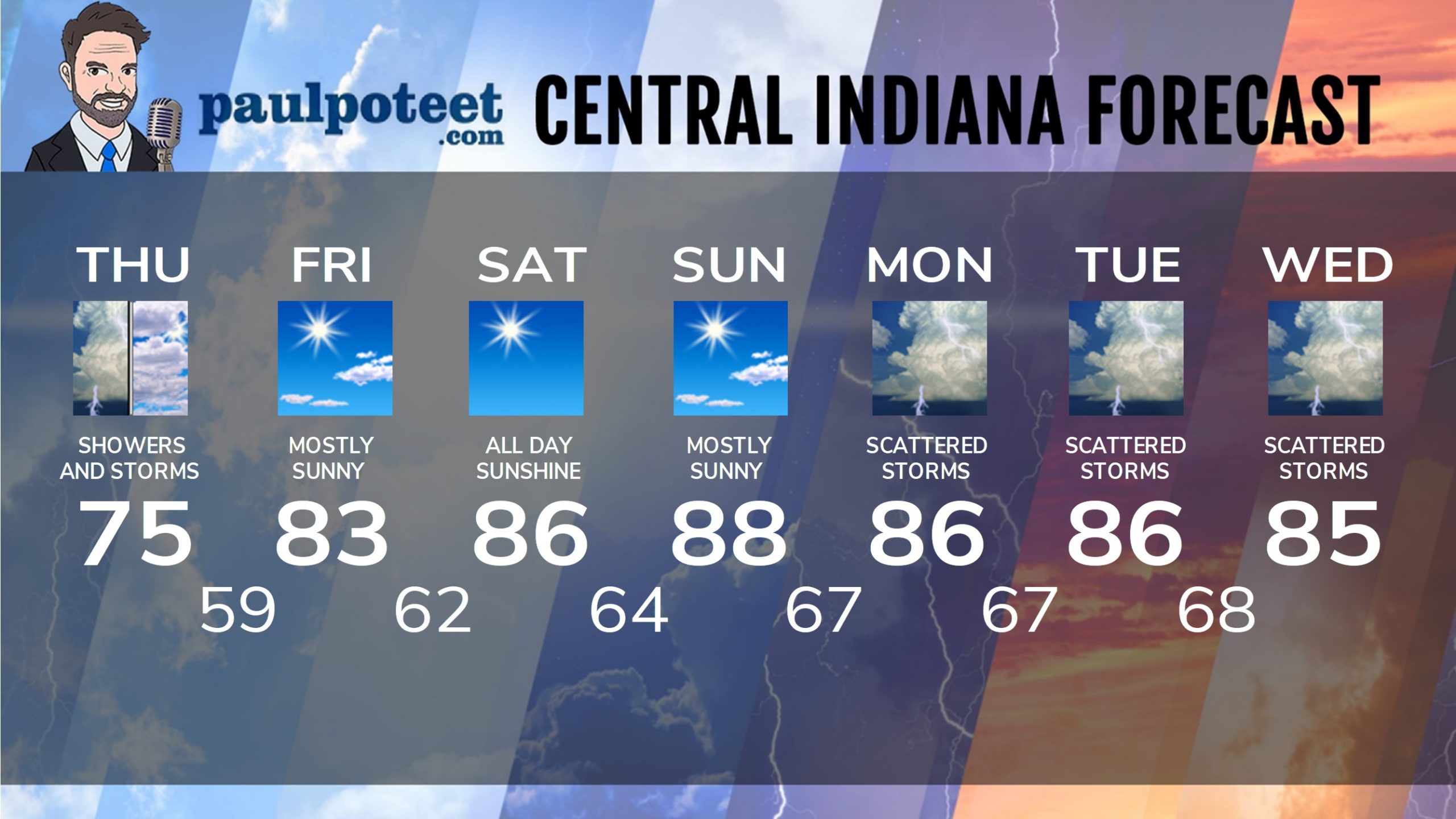
INDY SEVEN DAY FORECAST
Today: Scattered morning showers and storms, diminishing in the afternoon. High 75.
Tonight: Partly cloudy. Low 59.
Friday: Mostly sunny. High 83.
Friday Night: Mostly clear. Low 62.
Saturday: Sunny. High 86.
Saturday Night: Mostly clear. Low 64.
Sunday: Mostly sunny. High 88.
Sunday Night: Partly cloudy. Low 67.
Monday: Partly sunny. Scattered showers and storms. High 86.
Monday Night: Partly cloudy. Low 67.
Tuesday: Partly sunny. Scattered showers and storms. High 86.
Tuesday Night: Partly cloudy. Isolated showers or storms. Low 68.
Wednesday: Partly sunny. Scattered showers and storms. High 85.
Never miss me! Subscribe for free. My Huge Radar has real-time weather tracking, current temperatures, and severe weather watches and warnings. Get detailed Indiana conditions by clicking here. Click here to see my central Indiana 7-Day Forecast. Follow these links to get my forecasts for Lafayette, Muncie, Hendricks County, and Hamilton County. Need a second opinion? Click here for central Indiana National Weather Service forecasts. (Some charts via WeatherBELL.)


