Nothing like last Sunday, but there were some overnight and early morning showers drifting southward through central Indiana. Gotta protect those plants one…more…time late tonight and Wednesday morning. High pressure will nose into the area and clear things out heading into the middle of the week.

Above normal temps should return next week. Indy is running a hefty 6.6 degrees below normal so far for May. We are close to even on precipitation for the month, and since March 1, which is the start of meteorological Spring. We’re about an inch behind year-to-date.
Never miss me! Subscribe for free. My Huge Radar has real-time weather tracking, current temperatures, and severe weather watches and warnings. Get detailed Indiana conditions by clicking here. Click here to see my central Indiana 7-Day Forecast. Follow these links to get my forecasts for Lafayette, Muncie, Hendricks County, and Hamilton County. Need a second opinion? Click here for central Indiana National Weather Service forecasts. (Some charts via WeatherBELL.)
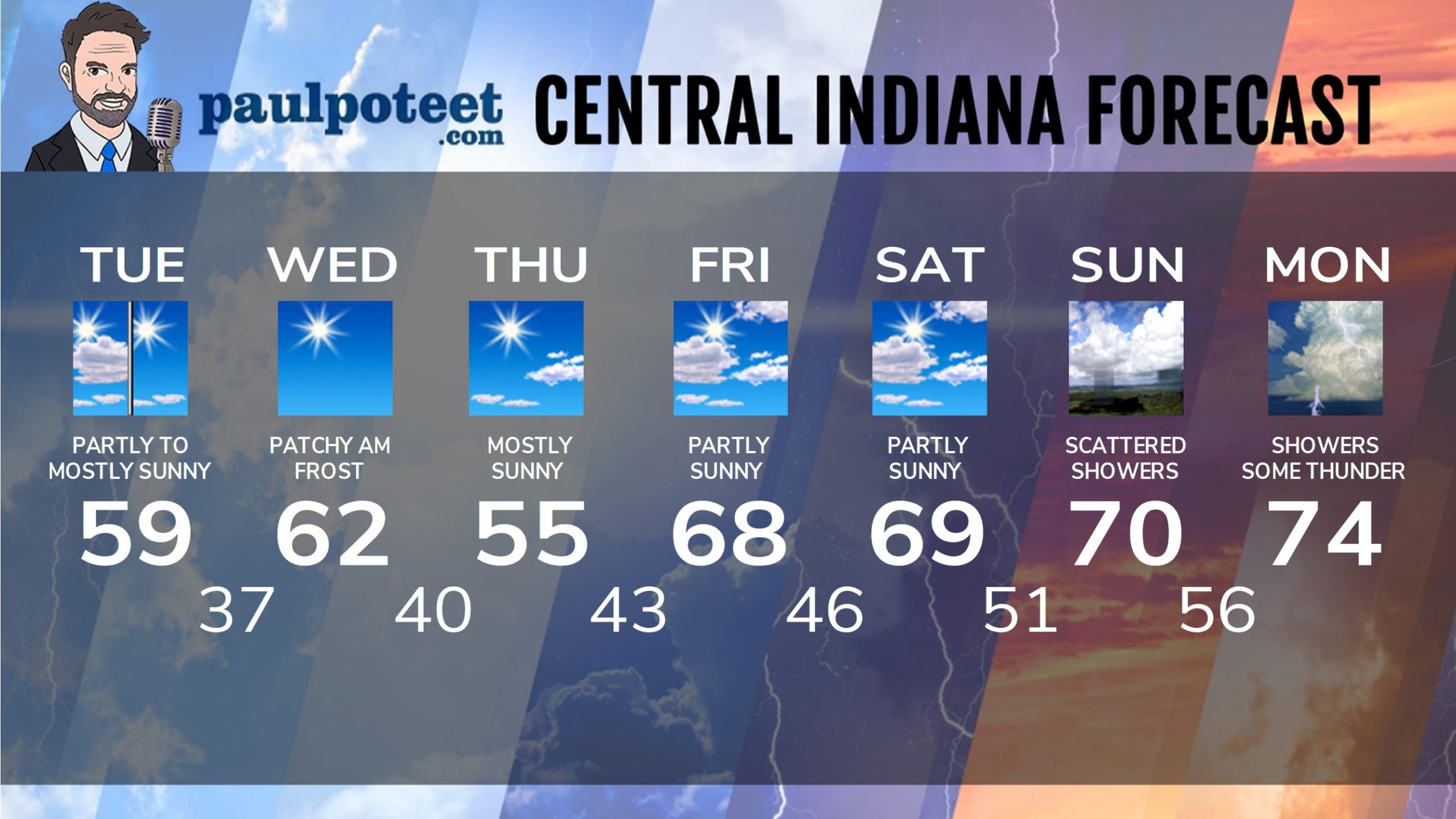
INDY SEVEN DAY FORECAST
Today: Early morning shower, then partly to mostly sunny. High 59.
Tonight: Partly cloudy. Low 37.
Wednesday: Patchy morning frost, then sunny. High 62.
Wednesday Night: Mostly clear. Low 40.
Thursday: Mostly sunny. High 66.
Thursday Night: Mostly clear. Low 43.
Friday: Partly sunny. High 68.
Friday Night: Partly cloudy. Low 46.
Saturday: Partly sunny. High 69.
Saturday Night: Partly cloudy. Low 51.
Sunday: Partly sunny, with some scattered showers. High 70.
Sunday Night: Scattered showers. Low 56.
Monday: Scattered showers and some thunder possible. High 74.
Never miss me! Subscribe for free. My Huge Radar has real-time weather tracking, current temperatures, and severe weather watches and warnings. Get detailed Indiana conditions by clicking here. Click here to see my central Indiana 7-Day Forecast. Follow these links to get my forecasts for Lafayette, Muncie, Hendricks County, and Hamilton County. Need a second opinion? Click here for central Indiana National Weather Service forecasts. (Some charts via WeatherBELL.)


