Showers this weekend will be more numerous south of Indy. Here are two different computer-modeled rainfall totals.
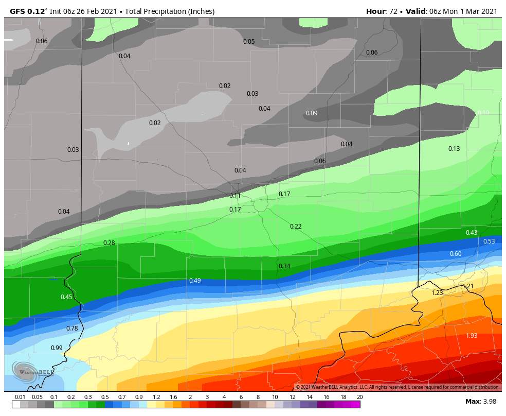
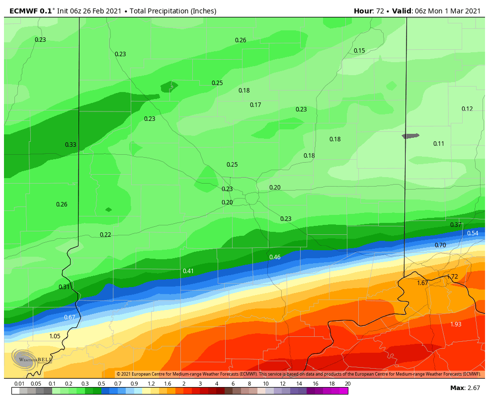
The windows for water: late Friday evening into early Saturday morning, and overnight Saturday night into Sunday morning. There will be many dry, MILD hours this weekend!
Interesting to watch the snow cover retreat this past week!
Never miss me! Subscribe for free. My Huge Radar has real-time weather tracking, current temperatures, and severe weather watches and warnings. Get detailed Indiana conditions by clicking here. Click here to see my central Indiana 7-Day Forecast. Follow these links to get my forecasts for Lafayette, Muncie, Hendricks County, and Hamilton County. Need a second opinion? Click here for central Indiana National Weather Service forecasts. (Some charts via WeatherBELL.)
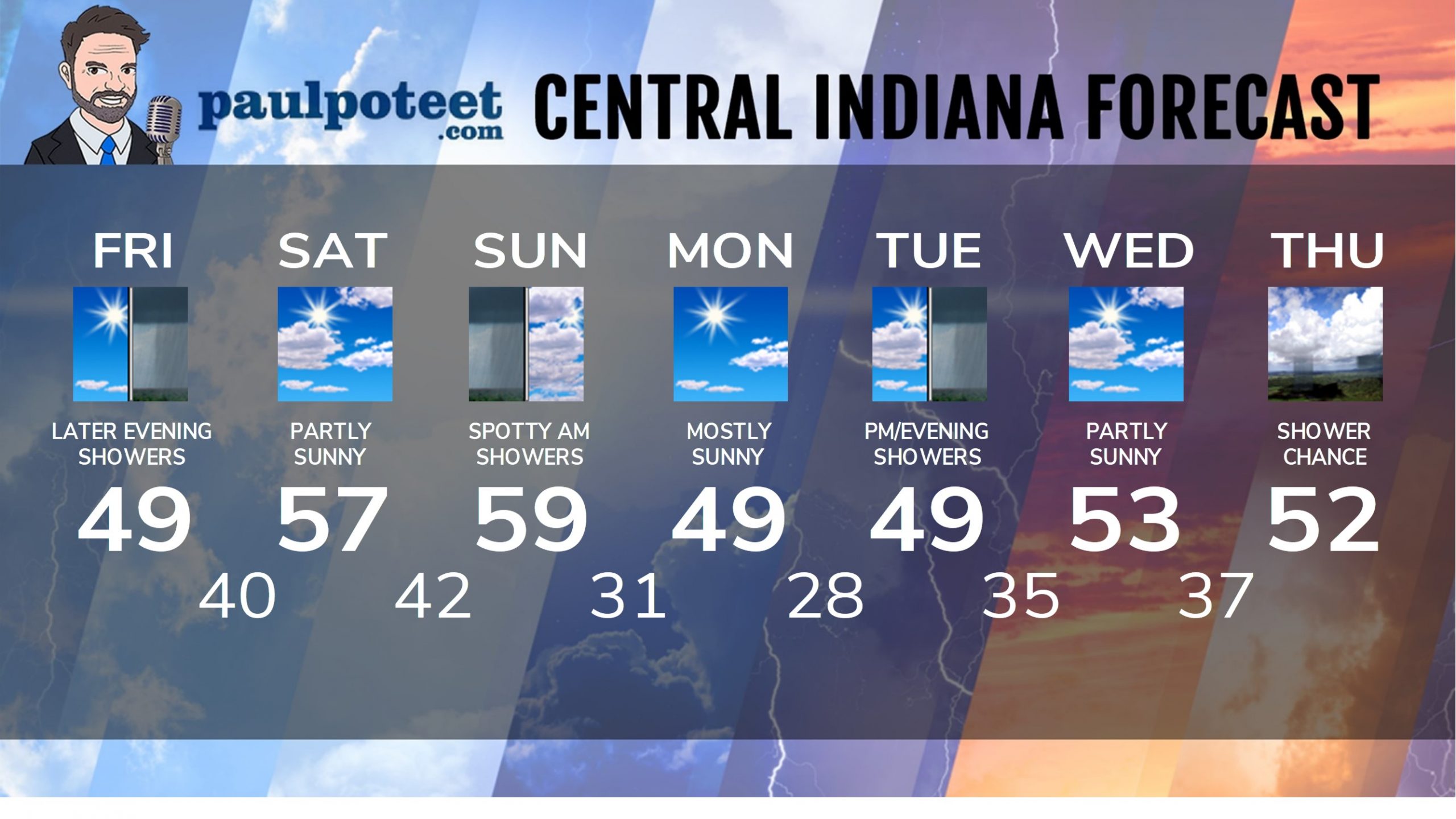
INDY SEVEN DAY FORECAST
Today: Mostly sunny. Wind gusting to 20 mph. High 49.
Tonight: Mostly cloudy. Spotty evening showers. Showers likely overnight. Low 40.
Saturday: Partly sunny. High 57.
Saturday Night: Partly cloudy evening. Scattered overnight showers. Low 42.
Sunday: Scattered morning showers, then mostly cloudy. High 59.
Sunday Night: Mostly to partly cloudy. Low 31.
Monday: Mostly sunny. High 49.
Monday Night: Mostly clear. Low 28.
Tuesday: Partly to mostly cloudy, with scattered showers by afternoon. High 49.
Tuesday Night: Partly cloudy. Spotty showers early. Low 35.
Wednesday: Partly sunny. High 53.
Wednesday Night: Partly cloudy. Low 37.
Thursday: Partly sunny. Spotty showers. High 52.
Never miss me! Subscribe for free. My Huge Radar has real-time weather tracking, current temperatures, and severe weather watches and warnings. Get detailed Indiana conditions by clicking here. Click here to see my central Indiana 7-Day Forecast. Follow these links to get my forecasts for Lafayette, Muncie, Hendricks County, and Hamilton County. Need a second opinion? Click here for central Indiana National Weather Service forecasts. (Some charts via WeatherBELL.)


So not that much rain, which is good. My backyard is pretty spongy after the snow melted. But a bit o… https://t.co/utng0aPbBR