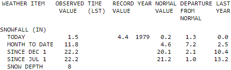
Add 1.5 inches from today on to the pile of February snow for Indianapolis. That makes 11.8 inches for the month, and 22.2 inches for the season. This week’s huge snowfall puts Indy’s season-to-date total exactly one inch above the average-to-date.
Never miss me! Subscribe for free. My Huge Radar has real-time weather tracking, current temperatures, and severe weather watches and warnings. Get detailed Indiana conditions by clicking here. Click here to see my central Indiana 7-Day Forecast. Follow these links to get my forecasts for Lafayette, Muncie, Hendricks County, and Hamilton County. Need a second opinion? Click here for central Indiana National Weather Service forecasts. (Some charts via WeatherBELL.)
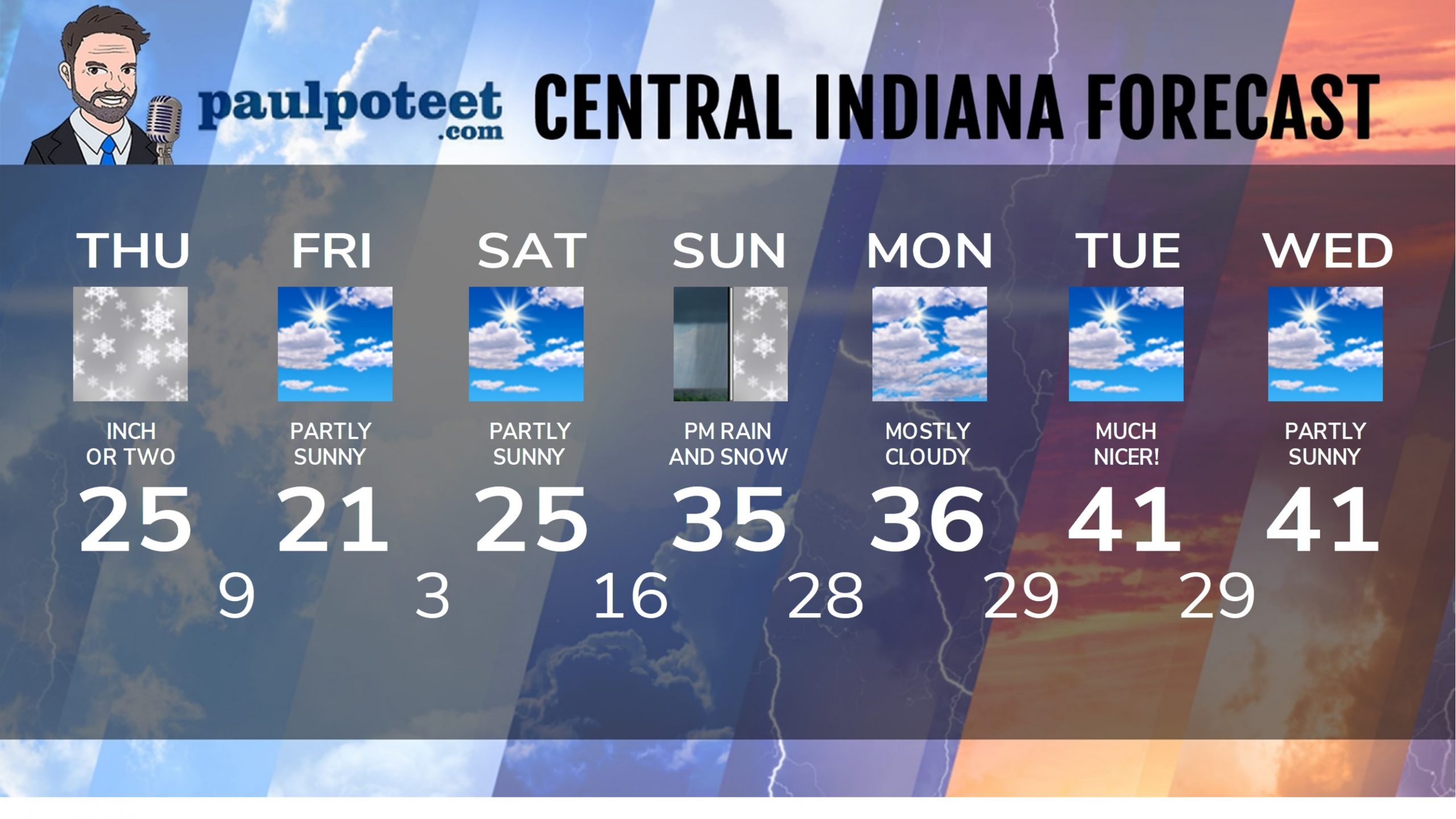
INDY SEVEN DAY FORECAST
Today: Snow, mainly in the morning and midday. Inch or two of total accumulation. High 25.
Tonight: Mostly to partly cloudy. Low 9.
Friday: Partly sunny. High 21.
Friday Night: Partly cloudy. Low 3.
Saturday: Partly sunny. High 25.
Saturday Night: Clouds increase. Low 16.
Sunday: Mostly cloudy. Rain and snow showers in the afternoon. High 35.
Sunday Night: Snow showers. Inch or two possible. Low 28.
Monday: Mostly cloudy. High 36.
Monday Night: Mostly cloudy evening. Partly cloudy overnight. Low 29.
Tuesday: Partly sunny. High 41.
Tuesday Night: Partly cloudy. Low 29.
Wednesday: Partly sunny. High 41.
Never miss me! Subscribe for free. My Huge Radar has real-time weather tracking, current temperatures, and severe weather watches and warnings. Get detailed Indiana conditions by clicking here. Click here to see my central Indiana 7-Day Forecast. Follow these links to get my forecasts for Lafayette, Muncie, Hendricks County, and Hamilton County. Need a second opinion? Click here for central Indiana National Weather Service forecasts. (Some charts via WeatherBELL.)


