The storm has already produced a 60 mph wind gust at Shelbyville. The peak gust so far at Indy has been 43 mph, it’s been 38 mph in Muncie. The Wind Advisory continues until 4am Saturday, but it will be breezy all weekend.
Rain totals as of 1:30 pm:
1.14"  TERRE HAUTE
 .63"  BLOOMINGTON
 .58"  MUNCIE
 .51"  LAFAYETTE
 .21"  KOKOMO
 .20"  MUNCIE
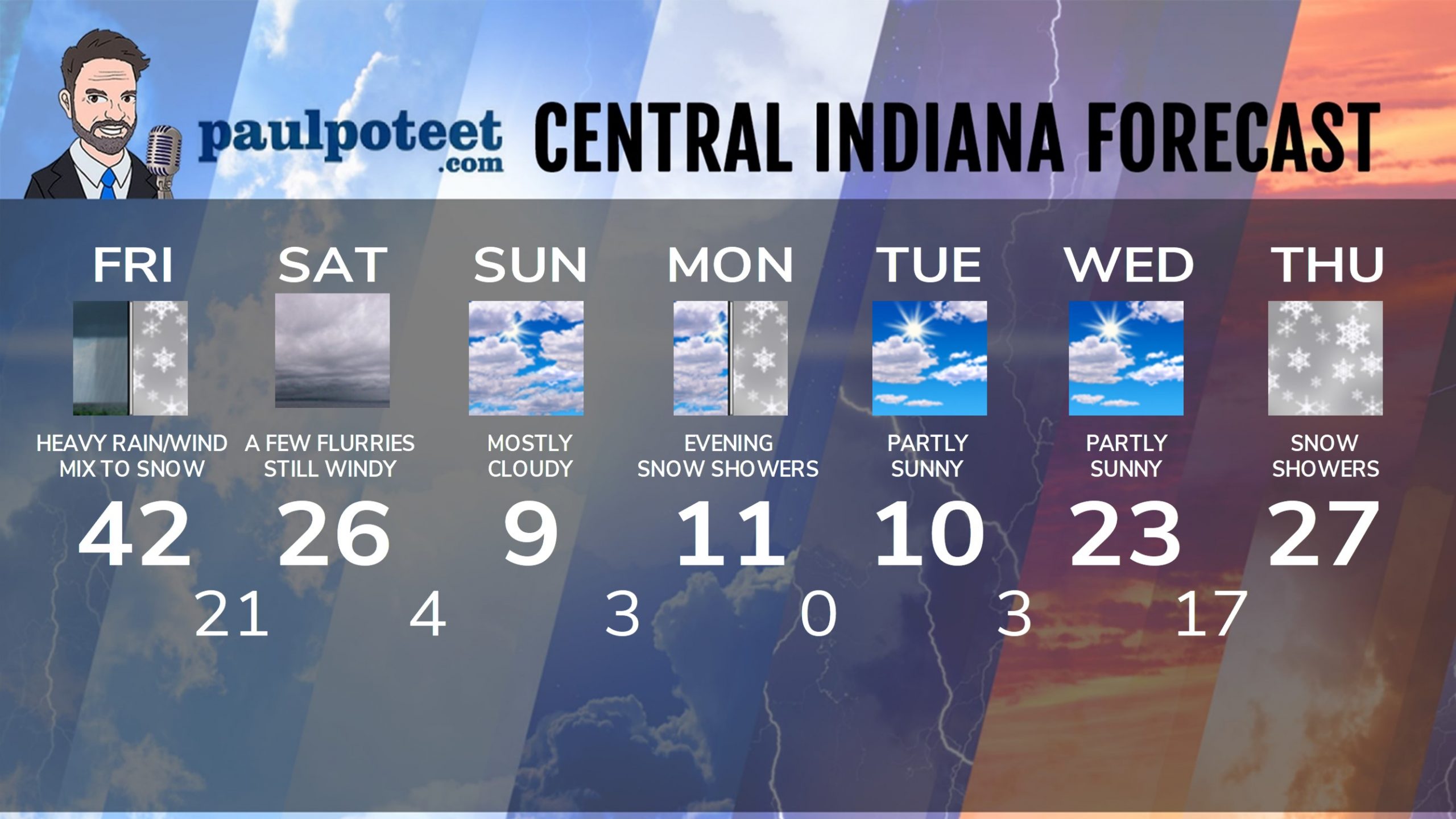
INDY SEVEN DAY FORECAST
Friday: WIND ADVISORY starts at 10am. Rainy and windy. Rain will be heavy at times. Wind gusts to 50 mph by afternoon. Rain may mix with snow in the afternoon. Total rainfall up to an inch. High 41.
Friday Night: WIND ADVISORY. Rain mixes with, and changes to snow. Around an inch of snow expected. Wind gusting to 55 mph. Low 21.
Saturday: Cloudy, with a few flurries or snow showers. Wind gusts to 40 mph. High 26.
Saturday Night: Mostly cloudy, with a few flurries. Wind gusts to 30 mph. Low 4.
Sunday: Mostly cloudy. Wind gusts to 30 mph. High 9.
Sunday Night:Mostly cloudy. Low 3.
Monday: Mostly cloudy. High 9.
Monday Night: Mostly cloudy. Snow showers possible. Possible dusting. Low 0.
Tuesday: Partly sunny. High 8.
Tuesday Night: Partly cloudy. Low 2.
Wednesday: Partly sunny. High 22.
Wednesday Night: Mostly cloudy. Low 16.
Thursday: Snow showers. Light accumulations possible. High 26.
Never miss me! Subscribe for free. My Huge Radar has real-time weather tracking, current temperatures, and severe weather watches and warnings. Get detailed Indiana conditions by clicking here. Click here to see my central Indiana 7-Day Forecast. Follow these links to get my forecasts for Lafayette, Muncie, Hendricks County, and Hamilton County. Need a second opinion? Click here for central Indiana National Weather Service forecasts. (Some charts via WeatherBELL.)


